Rouvray (Eure)
Rouvray ist eine französische Gemeinde mit 259 Einwohnern (Stand 1. Januar 2019) im Département Eure in der Region Normandie (vor 2016 Haute-Normandie). Sie gehört zum Arrondissement Les Andelys (bis 2017 Évreux) und zum Kanton Pacy-sur-Eure. Die Einwohner werden Rouvrayens genannt.
| Rouvray | ||
|---|---|---|

|
| |
| Staat | Frankreich | |
| Region | Normandie | |
| Département (Nr.) | Eure (27) | |
| Arrondissement | Les Andelys | |
| Kanton | Pacy-sur-Eure | |
| Gemeindeverband | Seine Normandie Agglomération | |
| Koordinaten | 49° 4′ N, 1° 20′ O | |
| Höhe | 77–127 m | |
| Fläche | 2,49 km² | |
| Einwohner | 259 (1. Januar 2019) | |
| Bevölkerungsdichte | 104 Einw./km² | |
| Postleitzahl | 27120 | |
| INSEE-Code | 27501 | |
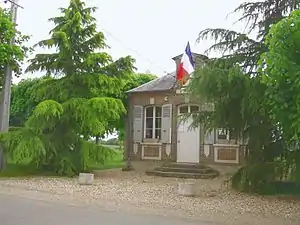 Rathaus (Mairie) von Rouvray | ||

Geografie
Rouvray liegt etwa 19 Kilometer ostnordöstlich von Évreux. Umgeben wird Rouvray von den Nachbargemeinden Chambray im Norden und Westen, Houlbec-Cocherel im Osten und Nordosten sowie Ménilles im Süden und Südosten.
Bevölkerungsentwicklung
| Jahr | 1962 | 1968 | 1975 | 1982 | 1990 | 1999 | 2006 | 2018 |
| Einwohner | 53 | 55 | 59 | 54 | 111 | 166 | 240 | 258 |
| Quellen: Cassini und INSEE | ||||||||
Sehenswürdigkeiten

Kapelle Saint-Martin
- Kapelle Saint-Martin aus dem 15./16. Jahrhundert
This article is issued from Wikipedia. The text is licensed under Creative Commons - Attribution - Sharealike. The authors of the article are listed here. Additional terms may apply for the media files, click on images to show image meta data.