La Heunière
La Heunière ist eine französische Gemeinde mit 431 Einwohnern (Stand 1. Januar 2019) im Département Eure in der Region Normandie (vor 2016 Haute-Normandie). Sie gehört zum Arrondissement Les Andelys (bis 2017 Évreux) und zum Kanton Pacy-sur-Eure. Die Einwohner werden Heuniérois genannt.
| La Heunière | ||
|---|---|---|
.svg.png.webp)
|
| |
| Staat | Frankreich | |
| Region | Normandie | |
| Département (Nr.) | Eure (27) | |
| Arrondissement | Les Andelys | |
| Kanton | Pacy-sur-Eure | |
| Gemeindeverband | Seine Normandie Agglomération | |
| Koordinaten | 49° 4′ N, 1° 25′ O | |
| Höhe | 122–143 m | |
| Fläche | 3,07 km² | |
| Einwohner | 431 (1. Januar 2019) | |
| Bevölkerungsdichte | 140 Einw./km² | |
| Postleitzahl | 27950 | |
| INSEE-Code | 27336 | |
| Website | https://laheuniere.fr/ | |

Geografie
La Heunière liegt etwa 23 Kilometer ostnordöstlich von Évreux. Umgeben wird La Heunière von den Nachbargemeinden Saint-Vincent-des-Bois im Norden und Westen, Saint-Marcel im Nordosten sowie Douains im Süden und Osten.
Durch die Gemeinde führt die Autoroute A13.
Bevölkerungsentwicklung
| Jahr | 1962 | 1968 | 1975 | 1982 | 1990 | 1999 | 2006 | 2018 |
| Einwohner | 142 | 126 | 135 | 195 | 234 | 241 | 250 | 407 |
| Quellen: Cassini und INSEE | ||||||||
Sehenswürdigkeiten
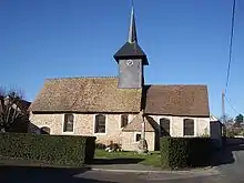
Kirche Saint-Jean-Baptiste
- Kirche Saint-Jean-Baptiste
This article is issued from Wikipedia. The text is licensed under Creative Commons - Attribution - Sharealike. The authors of the article are listed here. Additional terms may apply for the media files, click on images to show image meta data.