Port-Mort
| Port-Mort | ||
|---|---|---|
|
| |
| Staat | Frankreich | |
| Region | Normandie | |
| Département (Nr.) | Eure (27) | |
| Arrondissement | Les Andelys | |
| Kanton | Les Andelys | |
| Gemeindeverband | Seine Normandie Agglomération | |
| Koordinaten | 49° 10′ N, 1° 25′ O | |
| Höhe | 8–138 m | |
| Fläche | 12,19 km² | |
| Einwohner | 909 (1. Januar 2019) | |
| Bevölkerungsdichte | 75 Einw./km² | |
| Postleitzahl | 27940 | |
| INSEE-Code | 27473 | |
| Website | http://www.port-mort.com/ | |
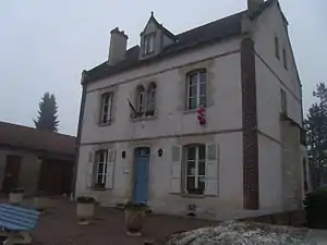 Rathaus (Mairie) von Port-Mort | ||

Port-Mort ist eine französische Gemeinde mit 909 Einwohnern (Stand: 1. Januar 2019) im Département Eure in der Region Normandie. Sie gehört zum Arrondissement Les Andelys und zum Kanton Les Andelys. Die Einwohner werden Pormortais genannt.
Geographie
Port-Mort liegt etwa 50 Kilometer südöstlich von Rouen an der Seine. Nachbargemeinden von Port-Mort sind Bouafles im Norden, Hennezis im Nordosten, Notre-Dame-d’Isle im Süden und Osten, Saint-Pierre-la-Garenne im Süden und Südwesten, Gaillon im Westen sowie Courcelles-sur-Seine im Nordwesten.
Bevölkerungsentwicklung
| Jahr | 1962 | 1968 | 1975 | 1982 | 1990 | 1999 | 2006 | 2013 |
| Einwohner | 441 | 431 | 563 | 672 | 839 | 820 | 1.008 | 937 |
| Quelle: Cassini und INSEE | ||||||||
Sehenswürdigkeiten
- Menhir Gravier de Gargantua (Port-Mort) seit 1923 Monument historique
- Kirche Saint-Pierre
- Burg (Château-Neuf)
- Schloss aus dem 17./18. Jahrhundert
- Grabesdenkmal des Heiligen Ethbin
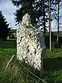 Menhir von Port-Mort
 Kirche Saint-Pierre
 Burg
Burg Grabesdenkmal des Heiligen Ethbin
This article is issued from Wikipedia. The text is licensed under Creative Commons - Attribution - Sharealike. The authors of the article are listed here. Additional terms may apply for the media files, click on images to show image meta data.