Saint-Flovier
Saint-Flovier ist eine Gemeinde im französischen Département Indre-et-Loire in der Region Centre-Val de Loire. Sie gehört zum Arrondissement Loches und zum Kanton Descartes. Sie grenzt im Nordwesten an Betz-le-Château, im Norden an Verneuil-sur-Indre, im Osten an Fléré-la-Rivière, im Südosten an Cléré-du-Bois und Obterre, im Süden an Charnizay und im Südwesten an La Celle-Guenand.
| Saint-Flovier | ||
|---|---|---|
| ||
| Staat | Frankreich | |
| Region | Centre-Val de Loire | |
| Département (Nr.) | Indre-et-Loire (37) | |
| Arrondissement | Loches | |
| Kanton | Descartes | |
| Gemeindeverband | Loches Sud Touraine | |
| Koordinaten | 46° 58′ N, 1° 2′ O | |
| Höhe | 102–146 m | |
| Fläche | 29,49 km² | |
| Einwohner | 571 (1. Januar 2019) | |
| Bevölkerungsdichte | 19 Einw./km² | |
| Postleitzahl | 37600 | |
| INSEE-Code | 37218 | |

Bevölkerungsentwicklung
| Jahr | 1962 | 1968 | 1975 | 1982 | 1990 | 1999 | 2008 | 2017 |
|---|---|---|---|---|---|---|---|---|
| Einwohner | 954 | 856 | 750 | 696 | 636 | 605 | 602 | 566 |
Sehenswürdigkeiten
- neugotische Kirche Saint-Flovier aus dem Jahr 1747, erneuert im Jahr 1886
- Schloss Roulet aus dem 14. Jahrhundert
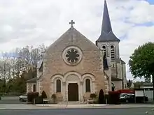
Kirche Saint-Flovier
Literatur
- Le Patrimoine des Communes d’Indre-et-Loire. Flohic Editions, Band 1, Paris 2001, ISBN 2-84234-115-5, S. 564–566.
Weblinks
Commons: Saint-Flovier – Sammlung von Bildern, Videos und Audiodateien
This article is issued from Wikipedia. The text is licensed under Creative Commons - Attribution - Sharealike. The authors of the article are listed here. Additional terms may apply for the media files, click on images to show image meta data.