Charnizay
Charnizay ist eine Gemeinde im französischen Département Indre-et-Loire in der Region Centre-Val de Loire. Sie gehört zum Kanton Descartes und zum Arrondissement Loches.
| Charnizay | ||
|---|---|---|
| ||
| Staat | Frankreich | |
| Region | Centre-Val de Loire | |
| Département (Nr.) | Indre-et-Loire (37) | |
| Arrondissement | Loches | |
| Kanton | Descartes | |
| Gemeindeverband | Loches Sud Touraine | |
| Koordinaten | 46° 55′ N, 0° 59′ O | |
| Höhe | 84–147 m | |
| Fläche | 53,25 km² | |
| Einwohner | 501 (1. Januar 2019) | |
| Bevölkerungsdichte | 9 Einw./km² | |
| Postleitzahl | 37290 | |
| INSEE-Code | 37061 | |
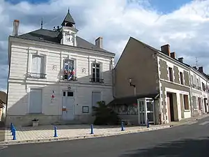 Mairie Charnizay | ||

Lage
Charnizay liegt am Fluss Aigronne. Die Gemeinde grenzt im Norden an Saint-Flovier, im Osten an Obterre, im Südosten an Azay-le-Ferron (Berührungspunkt), im Süden an Bossay-sur-Claise, im Westen an Le Petit-Pressigny und im Nordwesten an La Celle-Guenand. Zu Charnizay gehören neben der Hauptsiedlung auch die Weiler Belletière, Limeray, La Tanchonniere, Saint-Michel, La Cornetterie, Asnière, Le Champ und L’Ormeau.
Bevölkerungsentwicklung
| Jahr | 1962 | 1968 | 1975 | 1982 | 1990 | 1999 | 2008 | 2015 |
|---|---|---|---|---|---|---|---|---|
| Einwohner | 930 | 876 | 738 | 615 | 557 | 523 | 483 | 509 |
Sehenswürdigkeiten
- Dolmen Les Palets de Gargantua, zwei Kilometer nordöstlich von Charnizay
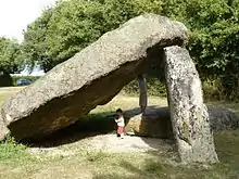
Dolmen Les Palets de Gargantua
Literatur
- Le Patrimoine des Communes d’Indre-et-Loire. Flohic Editions, Band 2, Paris 2001, ISBN 2-84234-115-5, S. 1099–1101.
Weblinks
Commons: Charnizay – Sammlung von Bildern, Videos und Audiodateien
This article is issued from Wikipedia. The text is licensed under Creative Commons - Attribution - Sharealike. The authors of the article are listed here. Additional terms may apply for the media files, click on images to show image meta data.