Morand
Morand ist eine französische Gemeinde mit 343 Einwohnern (Stand: 1. Januar 2019) im Département Indre-et-Loire in der Region Centre-Val de Loire; sie gehört zum Arrondissement Loches und zum Kanton Château-Renault. Die Einwohner werden Morandais genannt.
| Morand | ||
|---|---|---|
.svg.png.webp)
|
| |
| Staat | Frankreich | |
| Region | Centre-Val de Loire | |
| Département (Nr.) | Indre-et-Loire (37) | |
| Arrondissement | Loches | |
| Kanton | Château-Renault | |
| Gemeindeverband | Castelrenaudais | |
| Koordinaten | 47° 34′ N, 1° 1′ O | |
| Höhe | 104–147 m | |
| Fläche | 14,70 km² | |
| Einwohner | 343 (1. Januar 2019) | |
| Bevölkerungsdichte | 23 Einw./km² | |
| Postleitzahl | 37110 | |
| INSEE-Code | 37160 | |
| Website | https://www.morand-online.fr/ | |
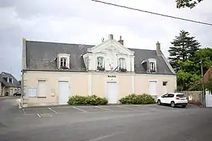 Rathaus (Mairie) von Morand | ||

Geographie
Morand liegt etwa 30 Kilometer nordöstlich von Tours. Umgeben wird Morand von den Nachbargemeinden Saint-Cyr-du-Gault im Norden, Saint-Nicolas-des-Motets im Osten und Nordosten, Dame-Marie-les-Bois im Südosten, Autrèche im Süden, Auzouer-en-Touraine im Westen sowie Saunay im Nordwesten.
Durch die Gemeinde führt die Autoroute A10.
Bevölkerungsentwicklung
| Jahr | 1962 | 1968 | 1975 | 1982 | 1990 | 1999 | 2006 | 2018 |
| Einwohner | 260 | 237 | 217 | 218 | 242 | 235 | 280 | 342 |
| Quellen: Cassini und INSEE | ||||||||
Sehenswürdigkeiten
.jpg.webp)
Kirche Saint-Jean-Baptiste
- Kirche Saint-Jean-Baptiste
Literatur
- Le Patrimoine des Communes d’Indre-et-Loire. Flohic Editions, Band 1, Paris 2001, ISBN 2-84234-115-5, S. 406–407.
Weblinks
Commons: Morand – Sammlung von Bildern, Videos und Audiodateien
This article is issued from Wikipedia. The text is licensed under Creative Commons - Attribution - Sharealike. The authors of the article are listed here. Additional terms may apply for the media files, click on images to show image meta data.