Chemillé-sur-Indrois
Chemillé-sur-Indrois ist eine Gemeinde im französischen Département Indre-et-Loire in der Region Centre-Val de Loire. Sie gehört zum Arrondissement Loches und zum Kanton Loches. Sie grenzt im Westen und im Norden an Genillé, im Nordosten an Beaumont-Village, im Osten an Montrésor, im Südosten an Villeloin-Coulangé, im Süden an Loché-sur-Indrois und im Südwesten an Sennevières.
| Chemillé-sur-Indrois | ||
|---|---|---|
| ||
| Staat | Frankreich | |
| Region | Centre-Val de Loire | |
| Département (Nr.) | Indre-et-Loire (37) | |
| Arrondissement | Loches | |
| Kanton | Loches | |
| Gemeindeverband | Loches Sud Touraine | |
| Koordinaten | 47° 10′ N, 1° 10′ O | |
| Höhe | 82–142 m | |
| Fläche | 24,89 km² | |
| Einwohner | 230 (1. Januar 2019) | |
| Bevölkerungsdichte | 9 Einw./km² | |
| Postleitzahl | 37460 | |
| INSEE-Code | 37069 | |

Bevölkerungsentwicklung
| Jahr | 1962 | 1968 | 1975 | 1982 | 1990 | 1999 | 2008 | 2017 |
|---|---|---|---|---|---|---|---|---|
| Einwohner | 387 | 339 | 273 | 250 | 207 | 197 | 218 | 222 |
Sehenswürdigkeiten
- Chartreuse Saint-Jean du Liget
- Kapelle Saint-Jean-du-Liget in Sennevières
- Hochburg „Corroirie du Liget“, Monument historique
- Kirche Saint-Vincent
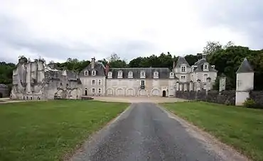 Kartause Liget
 Corroirie du Liget
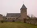 Kirche Saint-Vincent
_(34554723312).jpg.webp) Diese Tafel an der Grenze zu Montrésor zeugt von einer vormaligen Eisenbahnlinie.
Diese Tafel an der Grenze zu Montrésor zeugt von einer vormaligen Eisenbahnlinie.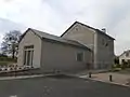 Mairie Chemillé-sur-Indrois, ehemaliges Bahnhofsgebäude
Literatur
- Le Patrimoine des Communes d’Indre-et-Loire. Flohic Editions, Band 2, Paris 2001, ISBN 2-84234-115-5, S. 975–978.
Weblinks
Commons: Chemillé-sur-Indrois – Sammlung von Bildern, Videos und Audiodateien
This article is issued from Wikipedia. The text is licensed under Creative Commons - Attribution - Sharealike. The authors of the article are listed here. Additional terms may apply for the media files, click on images to show image meta data.