Blangy-sous-Poix
Blangy-sous-Poix (picardisch: Blangy-dsou-Poé) ist eine nordfranzösische Gemeinde mit 175 Einwohnern (Stand 1. Januar 2019) im Département Somme in der Region Hauts-de-France. Die Gemeinde liegt im Arrondissement Amiens, ist Teil der Communauté de communes Somme Sud-Ouest und gehört zum Kanton Poix-de-Picardie.
| Blangy-sous-Poix | ||
|---|---|---|
| ||
| Staat | Frankreich | |
| Region | Hauts-de-France | |
| Département (Nr.) | Somme (80) | |
| Arrondissement | Amiens | |
| Kanton | Poix-de-Picardie | |
| Gemeindeverband | Somme Sud-Ouest | |
| Koordinaten | 49° 46′ N, 2° 0′ O | |
| Höhe | 85–189 m | |
| Fläche | 8,08 km² | |
| Einwohner | 175 (1. Januar 2019) | |
| Bevölkerungsdichte | 22 Einw./km² | |
| Postleitzahl | 80290 | |
| INSEE-Code | 80106 | |
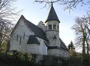
 Kirche Saint-Médard | ||
Geographie
Blangy liegt an der früheren Route nationale 320 im Tal des Flusses Poix (manchmal auch Nordarm der Évoissons genannt) zwischen Poix-de-Picardie, an das es unmittelbar angrenzt, und Famechon. Durch das Gemeindegebiet verläuft die Bahnstrecke von Amiens nach Rouen.
Einwohner
| 1962 | 1968 | 1975 | 1982 | 1990 | 1999 | 2006 | 2011 |
|---|---|---|---|---|---|---|---|
| 102 | 94 | 82 | 89 | 97 | 105 | 127 | 123 |
Verwaltung
Bürgermeister (maire) ist seit 2001 Alain Lesur.
Sehenswürdigkeiten
- Kirche Saint-Médard am Ostrand der Gemeinde.
This article is issued from Wikipedia. The text is licensed under Creative Commons - Attribution - Sharealike. The authors of the article are listed here. Additional terms may apply for the media files, click on images to show image meta data.
