Pargny-les-Bois
Pargny-les-Bois ist eine französische Gemeinde mit 135 Einwohnern (Stand: 1. Januar 2019) im Département Aisne in der Region Hauts-de-France. Sie gehört zum Arrondissement Laon und zum Kanton Marle.
| Pargny-les-Bois | ||
|---|---|---|
| ||
| Staat | Frankreich | |
| Region | Hauts-de-France | |
| Département (Nr.) | Aisne (02) | |
| Arrondissement | Laon | |
| Kanton | Marle | |
| Gemeindeverband | Communauté de communes du Pays de la Serre | |
| Koordinaten | 49° 44′ N, 3° 37′ O | |
| Höhe | 81–137 m | |
| Fläche | 6,89 km² | |
| Einwohner | 135 (1. Januar 2019) | |
| Bevölkerungsdichte | 20 Einw./km² | |
| Postleitzahl | 02270 | |
| INSEE-Code | 02591 | |
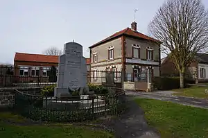 Mairie und Kriegerdenkmal in Pargny-les-Bois | ||

Lage
Die Gemeinde liegt in der Landschaft Picardie. Sie grenzt im Nordwesten an La Ferté-Chevresis, im Norden an Chevresis-Monceau, im Osten an Bois-lès-Pargny, im Südosten an Crécy-sur-Serre und im Südwesten an Montigny-sur-Crécy.
Bevölkerungsentwicklung
| Jahr | 1962 | 1968 | 1975 | 1982 | 1990 | 1999 | 2008 | 2015 |
|---|---|---|---|---|---|---|---|---|
| Einwohner | 144 | 153 | 161 | 139 | 153 | 137 | 135 | 126 |
This article is issued from Wikipedia. The text is licensed under Creative Commons - Attribution - Sharealike. The authors of the article are listed here. Additional terms may apply for the media files, click on images to show image meta data.