Barenton-sur-Serre
Barenton-sur-Serre ist eine französische Gemeinde mit 133 Einwohnern (Stand 1. Januar 2019) im Département Aisne in der Region Hauts-de-France (vor 2016 Picardie). Sie gehört zum Arrondissement Laon, zum Kanton Marle und zum Gemeindeverband Pays de la Serre.
| Barenton-sur-Serre | ||
|---|---|---|
| ||
| Staat | Frankreich | |
| Region | Hauts-de-France | |
| Département (Nr.) | Aisne (02) | |
| Arrondissement | Laon | |
| Kanton | Marle | |
| Gemeindeverband | Pays de la Serre | |
| Koordinaten | 49° 40′ N, 3° 41′ O | |
| Höhe | 61–122 m | |
| Fläche | 7,99 km² | |
| Einwohner | 133 (1. Januar 2019) | |
| Bevölkerungsdichte | 17 Einw./km² | |
| Postleitzahl | 02270 | |
| INSEE-Code | 02048 | |
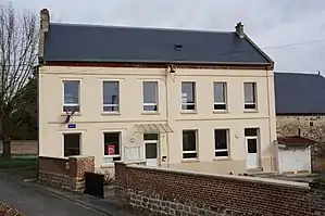 Rathaus (Mairie) von Barenton-sur-Serre | ||

Geografie
Das Gemeindegebiet wird vom Fluss Souche durchquert, in den hier sein Nebenfluss Barentons einmündet.
Umgeben wird Barenton-sur Serre von den Nachbargemeinden Froidmont-Cohartille im Nordosten, Grandlup-et-Fay im Südosten, Verneuil-sur-Serre im Süden, Barenton-Cel im Südwesten, Chalandry im Westen sowie Mortiers im Nordwesten.
Bevölkerungsentwicklung
| Jahr | 1962 | 1968 | 1975 | 1982 | 1990 | 1999 | 2006 | 2019 |
| Einwohner | 111 | 109 | 97 | 112 | 106 | 109 | 111 | 133 |
| Quellen: Cassini und INSEE | ||||||||
Sehenswürdigkeiten
- Kirche Saint-Martin
_%C3%A9glise_(02).JPG.webp)
Kirche Saint-Martin
This article is issued from Wikipedia. The text is licensed under Creative Commons - Attribution - Sharealike. The authors of the article are listed here. Additional terms may apply for the media files, click on images to show image meta data.