Barenton-Cel
Barenton-Cel ist eine französische Gemeinde mit 108 Einwohnern (Stand 1. Januar 2019) im Département Aisne in der Region Hauts-de-France (vor 2016 Picardie). Sie gehört zum Arrondissement Laon, zum Kanton Marle und zum Gemeindeverband Pays de la Serre.
| Barenton-Cel | ||
|---|---|---|
| ||
| Staat | Frankreich | |
| Region | Hauts-de-France | |
| Département (Nr.) | Aisne (02) | |
| Arrondissement | Laon | |
| Kanton | Marle | |
| Gemeindeverband | Pays de la Serre | |
| Koordinaten | 49° 39′ N, 3° 39′ O | |
| Höhe | 63–106 m | |
| Fläche | 6,69 km² | |
| Einwohner | 108 (1. Januar 2019) | |
| Bevölkerungsdichte | 16 Einw./km² | |
| Postleitzahl | 02000 | |
| INSEE-Code | 02047 | |
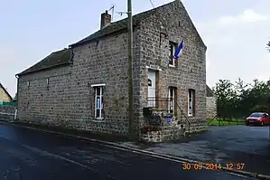 Rathaus (Mairie) von Barenton-Cel | ||

Geografie
Die Gemeinde Barenton-Cel liegt neun Kilometer nördlich der Départements-Hauptstadt Laon. Umgeben wird Barenton-Cel von den Nachbargemeinden Chalandry im Nordwesten und Norden, Barenton-sur-Serre im Nordosten, Verneuil-sur-Serre im Osten, Barenton-Bugny im Südosten, Aulnois-sous-Laon im Süden und Südwesten sowie Chéry-lès-Pouilly im Westen. Das Gemeindegebiet wird vom Fluss Barentons durchquert.
Bevölkerungsentwicklung
| Jahr | 1962 | 1968 | 1975 | 1982 | 1990 | 1999 | 2006 | 2019 |
| Einwohner | 147 | 108 | 129 | 147 | 141 | 133 | 148 | 108 |
| Quellen: Cassini und INSEE | ||||||||
Sehenswürdigkeiten
- Kirche Saint-Georges
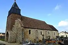
Kirche Saint-Georges
This article is issued from Wikipedia. The text is licensed under Creative Commons - Attribution - Sharealike. The authors of the article are listed here. Additional terms may apply for the media files, click on images to show image meta data.