Fleurbaix
Fleurbaix (niederländisch: Vloerbeek) ist eine französische Gemeinde mit 2.698 Einwohnern (Stand: 1. Januar 2019) im Département Pas-de-Calais in der Region Hauts-de-France. Sie gehört zum Arrondissement Béthune und zum Kanton Beuvry (bis 2015: Kanton Laventie). Die Einwohner werden Fleurbaisiens genannt.
| Fleurbaix | ||
|---|---|---|

|
| |
| Staat | Frankreich | |
| Region | Hauts-de-France | |
| Département (Nr.) | Pas-de-Calais (62) | |
| Arrondissement | Béthune | |
| Kanton | Beuvry | |
| Gemeindeverband | Flandre Lys | |
| Koordinaten | 50° 39′ N, 2° 50′ O | |
| Höhe | 16–20 m | |
| Fläche | 12,99 km² | |
| Einwohner | 2.698 (1. Januar 2019) | |
| Bevölkerungsdichte | 208 Einw./km² | |
| Postleitzahl | 62840 | |
| INSEE-Code | 62338 | |
| Website | http://fleurbaix.com/ | |
Geographie
Fleurbaix liegt in der historischen Region Flandern nahe der Grenze zum Département Nord. Die Gemeinde liegt am Bach Becque du Biez. Umgeben wird Fleurbaix von den Nachbargemeinden Erquinghem-Lys im Norden, Bois-Grenier im Nordosten, Le Maisnil im Osten, Fromelles im Südosten, Aubers im Süden, Laventie im Südwesten sowie Sailly-sur-la-Lys im Westen.
Bevölkerungsentwicklung
| Jahr | 1962 | 1968 | 1975 | 1982 | 1990 | 1999 | 2006 | 2011 |
| Einwohner | 1.437 | 1.457 | 1.647 | 1.993 | 2.221 | 2.480 | 2.674 | 2.635 |
Sehenswürdigkeiten

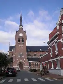
Kirche Notre-Dame-du-Joyel
- Kirche Notre-Dame du Joyel, erbaut 1929
- früheres Kartäuserkloster Notre-Dame des Sept Douleurs de la Boutillerie (bestand von 1618 bis 1792)
- Britischer Militärfriedhof Trou Aid Post Cemetery
This article is issued from Wikipedia. The text is licensed under Creative Commons - Attribution - Sharealike. The authors of the article are listed here. Additional terms may apply for the media files, click on images to show image meta data.
