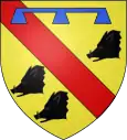
Vaudricourt (Pas-de-Calais)
| Vaudricourt | ||
|---|---|---|
|
| |
| Staat | Frankreich | |
| Region | Hauts-de-France | |
| Département (Nr.) | Pas-de-Calais (62) | |
| Arrondissement | Béthune | |
| Kanton | Nœux-les-Mines | |
| Gemeindeverband | Béthune-Bruay, Artois-Lys Romane | |
| Koordinaten | 50° 30′ N, 2° 38′ O | |
| Höhe | 29–52 m | |
| Fläche | 2,99 km² | |
| Einwohner | 1.054 (1. Januar 2019) | |
| Bevölkerungsdichte | 353 Einw./km² | |
| Postleitzahl | 62131 | |
| INSEE-Code | 62836 | |
| Website | http://www.vaudricourt.com/ | |

Vaudricourt ist eine französische Gemeinde mit 1.054 Einwohnern (Stand: 1. Januar 2019) im Département Pas-de-Calais in der Region Hauts-de-France. Sie gehört zum Arrondissement Béthune sowie zum Kanton Nœux-les-Mines (bis 2015: Kanton Barlin) und ist Mitglied des Gemeindeverbandes Béthune-Bruay, Artois-Lys Romane.
Geographie
Vaudricourt liegt etwa drei Kilometer südwestlich des Stadtzentrums von Béthune. Umgeben wird Vaudricourt von den Nachbargemeinden Fouquières-lès-Béthune im Norden und Nordwesten, Verquin im Osten, Drouvin-le-Marais im Südosten, Houchin im Süden sowie Hesdigneul-lès-Béthune im Westen.
Die Autoroute A26 führt durch die Gemeinde.
Bevölkerungsentwicklung
| 1962 | 1968 | 1975 | 1982 | 1990 | 1999 | 2006 | 2013 | |
|---|---|---|---|---|---|---|---|---|
| 460 | 454 | 668 | 897 | 863 | 867 | 886 | 886 | |
| Quelle: Cassini und INSEE | ||||||||
Sehenswürdigkeiten
- Kirche Notre-Dame aus dem 13. Jahrhundert, seit 1946 Monument historique
- Schloss aus dem 19. Jahrhundert
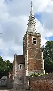
Kirche Notre-Dame
This article is issued from Wikipedia. The text is licensed under Creative Commons - Attribution - Sharealike. The authors of the article are listed here. Additional terms may apply for the media files, click on images to show image meta data.