Essars
Essars ist eine französische Gemeinde mit 1.755 Einwohnern (Stand: 1. Januar 2019) im Département Pas-de-Calais in der Region Hauts-de-France. Essars gehört zum Arrondissement Béthune und seit 2015 zum Kanton Beuvry (davor: Kanton Béthune-Est). Die Gemeinde ist Mitglied des Gemeindeverbandes Béthune-Bruay, Artois-Lys Romane.
| Essars | ||
|---|---|---|
|
| |
| Staat | Frankreich | |
| Region | Hauts-de-France | |
| Département (Nr.) | Pas-de-Calais (62) | |
| Arrondissement | Béthune | |
| Kanton | Beuvry | |
| Gemeindeverband | Béthune-Bruay, Artois-Lys Romane | |
| Koordinaten | 50° 33′ N, 2° 40′ O | |
| Höhe | 18–23 m | |
| Fläche | 3,63 km² | |
| Einwohner | 1.755 (1. Januar 2019) | |
| Bevölkerungsdichte | 483 Einw./km² | |
| Postleitzahl | 62400 | |
| INSEE-Code | 62310 | |
| Website | http://www.mairie-essars.fr/accueil2.htm | |
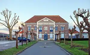 Rathaus (Mairie) von Essars | ||

Geographie
Essars liegt im Artois am Fluss Lawe und am Canal d'Aire à La Bassée. Umgeben wird Essars von den Nachbargemeinden Locon im Norden, Beuvry im Osten, Béthune im Süden sowie Annezin im Westen.
Bevölkerungsentwicklung
| 1962 | 1968 | 1975 | 1982 | 1990 | 1999 | 2006 | 2012 |
|---|---|---|---|---|---|---|---|
| 911 | 1.175 | 1.151 | 1.683 | 1.919 | 1.732 | 1.649 | 1.615 |
| Quelle: Cassini und INSEE | |||||||
Sehenswürdigkeiten
- Kirche Saint-Jacques, ursprünglich 1545 errichtet, nach dem Zweiten Weltkrieg neu errichtet
- Wegekreuz
- Britischer Militärfriedhof
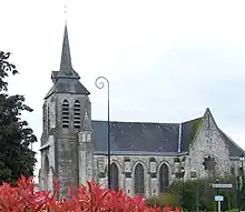
Kirche Saint-Jacques
This article is issued from Wikipedia. The text is licensed under Creative Commons - Attribution - Sharealike. The authors of the article are listed here. Additional terms may apply for the media files, click on images to show image meta data.