Givenchy-lès-la-Bassée
Givenchy-lès-la-Bassée ist eine französische Gemeinde mit 1.040 Einwohnern (Stand: 1. Januar 2019) im Pas-de-Calais in der Region Nord-Pas-de-Calais. Die Gemeinde gehört zum Arrondissement Béthune und zum Kanton Douvrin.
| Givenchy-lès-la-Bassée | ||
|---|---|---|

|
| |
| Staat | Frankreich | |
| Region | Hauts-de-France | |
| Département (Nr.) | Pas-de-Calais (62) | |
| Arrondissement | Béthune | |
| Kanton | Douvrin | |
| Gemeindeverband | Béthune-Bruay, Artois-Lys Romane | |
| Koordinaten | 50° 32′ N, 2° 46′ O | |
| Höhe | 19–31 m | |
| Fläche | 3,89 km² | |
| Einwohner | 1.040 (1. Januar 2019) | |
| Bevölkerungsdichte | 267 Einw./km² | |
| Postleitzahl | 62149 | |
| INSEE-Code | 62373 | |
| Website | http://www.givenchyleslabassee.fr/ | |
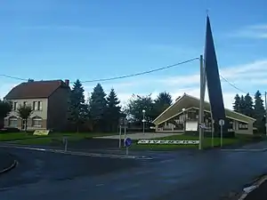
 Rathaus (Mairie) und Kirche Saint-Martin von Givenchy-lès-la-Bassée | ||
Geographie
Am Südrand von Givenchy-lès-la-Bassée führt der Canal d’Aire, ein Abschnitt des Großschifffahrtsweges Dünkirchen-Schelde, entlang. Umgeben wird Givenchy-lès-la-Bassée, acht Kilometer östlich von Béthune gelegen, von den Nachbargemeinden Festubert im Norden und Nordwesten, Violaines im Osten sowie Cuinchy im Westen.
Bevölkerungsentwicklung
| 1962 | 1968 | 1975 | 1982 | 1990 | 1999 | 2006 | 2012 |
|---|---|---|---|---|---|---|---|
| 473 | 521 | 554 | 748 | 803 | 813 | 837 | 998 |
| Quelle: Cassini und INSEE | |||||||
Sehenswürdigkeiten
- Kirche Saint-Martin
- Britischer Militärfriedhof
This article is issued from Wikipedia. The text is licensed under Creative Commons - Attribution - Sharealike. The authors of the article are listed here. Additional terms may apply for the media files, click on images to show image meta data.
