Ligny-lès-Aire
Ligny-lès-Aire ist eine französische Gemeinde mit 574 Einwohnern (Stand: 1. Januar 2019) im Département Pas-de-Calais in der Region Hauts-de-France. Sie gehört zum Arrondissement Béthune und zum Kanton Aire-sur-la-Lys (bis 2015: Kanton Norrent-Fontes).
| Ligny-lès-Aire | ||
|---|---|---|

|
| |
| Staat | Frankreich | |
| Region | Hauts-de-France | |
| Département (Nr.) | Pas-de-Calais (62) | |
| Arrondissement | Béthune | |
| Kanton | Aire-sur-la-Lys | |
| Gemeindeverband | Béthune-Bruay, Artois-Lys Romane | |
| Koordinaten | 50° 33′ N, 2° 21′ O | |
| Höhe | 52–132 m | |
| Fläche | 8,10 km² | |
| Einwohner | 574 (1. Januar 2019) | |
| Bevölkerungsdichte | 71 Einw./km² | |
| Postleitzahl | 62960 | |
| INSEE-Code | 62512 | |
| Website | http://lignylesaire.com/ | |
_mairie.JPG.webp) Rathaus (Mairie) von Ligny-lès-Aire | ||

Geographie
Ligny-lès-Aire liegt etwa 25 Kilometer westnordwestlich von Béthune. Umgeben wird Ligny-lès-Aire von den Nachbargemeinden Estrée-Blanche im Norden, Rely im Osten, Auchy-aux-Bois im Südosten, Westrehem im Süden, Febvin-Palfart im Westen und Südwesten sowie Enquin-les-Mines im Nordwesten.
Bevölkerungsentwicklung
| Jahr | 1962 | 1968 | 1975 | 1982 | 1990 | 1999 | 2006 | 2013 |
| Einwohner | 564 | 536 | 505 | 505 | 486 | 505 | 563 | 618 |
| Quelle: Cassini und INSEE | ||||||||
Sehenswürdigkeiten
- Kirche Saint-Pierre aus dem 16. Jahrhundert
- Kapelle Sainte-Berthe
- Ruine einer Windmühle
_%C3%A9glise_(1).JPG.webp) Kirche Saint-Pierre
Kirche Saint-Pierre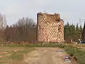 Ruine der Mühle
This article is issued from Wikipedia. The text is licensed under Creative Commons - Attribution - Sharealike. The authors of the article are listed here. Additional terms may apply for the media files, click on images to show image meta data.