Saint-Gelais
Saint-Gelais ist eine französische Gemeinde mit 2.136 Einwohnern (Stand: 1. Januar 2019) im Département Deux-Sèvres in der Region Nouvelle-Aquitaine. Sie gehört zum Arrondissement Niort und zum Kanton La Plaine Niortaise (bis 2015: Kanton Niort-Nord).
| Saint-Gelais | ||
|---|---|---|

|
| |
| Staat | Frankreich | |
| Region | Nouvelle-Aquitaine | |
| Département (Nr.) | Deux-Sèvres (79) | |
| Arrondissement | Niort | |
| Kanton | La Plaine Niortaise | |
| Gemeindeverband | Niortais | |
| Koordinaten | 46° 23′ N, 0° 23′ W | |
| Höhe | 30–93 m | |
| Fläche | 16,57 km² | |
| Einwohner | 2.136 (1. Januar 2019) | |
| Bevölkerungsdichte | 129 Einw./km² | |
| Postleitzahl | 79410 | |
| INSEE-Code | 79249 | |
| Website | http://www.saintgelais.fr/ | |

Geographie
Saint-Gelais liegt etwa acht Kilometer nordöstlich vom Stadtzentrum Niorts. Umgeben wird Saint-Gelais von den Nachbargemeinden Cherveux im Norden und Nordosten, François im Osten, Chauray im Süden, Niort im Südwesten sowie Échiré im Westen. Durch die Gemeinde führt die Autoroute A83.
Bevölkerungsentwicklung
| Jahr | 1962 | 1968 | 1975 | 1982 | 1990 | 1999 | 2006 | 2012 |
| Einwohner | 722 | 750 | 1.001 | 1.221 | 1.400 | 1.456 | 1.627 | 1.856 |
| Quelle: Cassini und INSEE | ||||||||
Sehenswürdigkeiten
- Kirche Saint-Gelais aus dem 12. Jahrhundert, Monument historique
- Reste der protestantischen Kirche, Monument historique
- Kleines Schloss, Monument historique
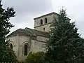 Kirche Saint-Gelais
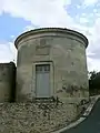 Rotunde der protestantischen Kirche
 Schoss Saint-Gelais
This article is issued from Wikipedia. The text is licensed under Creative Commons - Attribution - Sharealike. The authors of the article are listed here. Additional terms may apply for the media files, click on images to show image meta data.