Saint-Christophe-sur-Roc
Saint-Christophe-sur-Roc ist eine französische Gemeinde mit 569 Einwohnern (Stand: 1. Januar 2019) im Département Deux-Sèvres in der Region Nouvelle-Aquitaine (vor 2016: Poitou-Charentes). Sie gehört zum Arrondissement Niort und zum Kanton Autize-Égray (bis 2015: Kanton Champdeniers-Saint-Denis).
| Saint-Christophe-sur-Roc | ||
|---|---|---|
.svg.png.webp)
|
| |
| Staat | Frankreich | |
| Region | Nouvelle-Aquitaine | |
| Département (Nr.) | Deux-Sèvres (79) | |
| Arrondissement | Niort | |
| Kanton | Autize-Égray | |
| Gemeindeverband | Val de Gâtine | |
| Koordinaten | 46° 27′ N, 0° 21′ W | |
| Höhe | 65–139 m | |
| Fläche | 10,90 km² | |
| Einwohner | 569 (1. Januar 2019) | |
| Bevölkerungsdichte | 52 Einw./km² | |
| Postleitzahl | 79220 | |
| INSEE-Code | 79241 | |
| Website | https://www.stchristophesurroc.fr/ | |
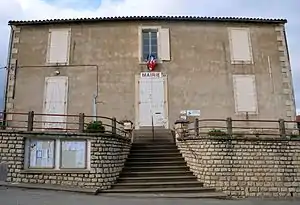 Rathaus (Mairie) von Saint-Christophe-sur-Roc | ||

Geographie
Saint-Christophe-sur-Roc liegt etwa 13 Kilometer nordnordöstlich von Niort. Umgeben wird Saint-Christophe-sur-Roc von den Nachbargemeinden Champdeniers im Norden und Westen, La Chapelle-Bâton im Osten sowie Cherveux im Süden.
Bevölkerungsentwicklung
| Jahr | 1962 | 1968 | 1975 | 1982 | 1990 | 1999 | 2006 | 2013 |
| Einwohner | 640 | 618 | 536 | 468 | 472 | 453 | 535 | 553 |
| Quelle: Cassini und INSEE | ||||||||
Sehenswürdigkeiten
- romanische Kirche Saint-Christophe
- Hosianna-Kreuz, 9 Meter hoch, Monument historique seit 1889
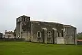 Kirche Saint-Christophe
 Hosianna-Kreuz
This article is issued from Wikipedia. The text is licensed under Creative Commons - Attribution - Sharealike. The authors of the article are listed here. Additional terms may apply for the media files, click on images to show image meta data.