Les Fosses
Les Fosses ist eine französische Gemeinde mit 439 Einwohnern (Stand: 1. Januar 2019) im Département Deux-Sèvres in der Region Nouvelle-Aquitaine (vor 2016 Poitou-Charentes). Sie gehört zum Arrondissement Niort und zum Kanton Mignon-et-Boutonne (bis 2015 Brioux-sur-Boutonne).
| Les Fosses | ||
|---|---|---|
| ||
| Staat | Frankreich | |
| Region | Nouvelle-Aquitaine | |
| Département (Nr.) | Deux-Sèvres (79) | |
| Arrondissement | Niort | |
| Kanton | Mignon-et-Boutonne | |
| Gemeindeverband | Mellois en Poitou | |
| Koordinaten | 46° 10′ N, 0° 21′ W | |
| Höhe | 51–101 m | |
| Fläche | 12,25 km² | |
| Einwohner | 439 (1. Januar 2019) | |
| Bevölkerungsdichte | 36 Einw./km² | |
| Postleitzahl | 79360 | |
| INSEE-Code | 79126 | |

Geographie
Les Fosses liegt etwa 19 Kilometer südsüdöstlich von Niort. Umgeben wird Les Fosses von den Nachbargemeinden Marigny im Norden und Westen, Saint-Romans-des-Champs im Norden, Brûlain im Nordosten, Secondigné-sur-Belle im Osten sowie Villiers-en-Bois im Süden und Südwesten.
Bevölkerungsentwicklung
| Jahr | 1962 | 1968 | 1975 | 1982 | 1990 | 1999 | 2006 | 2013 |
| Einwohner | 358 | 323 | 326 | 319 | 314 | 350 | 408 | 444 |
| Quelle: Cassini und INSEE | ||||||||
Sehenswürdigkeiten
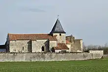
Kirche Sainte-Radegonde
- Kirche Sainte-Radegonde
This article is issued from Wikipedia. The text is licensed under Creative Commons - Attribution - Sharealike. The authors of the article are listed here. Additional terms may apply for the media files, click on images to show image meta data.