Aubigné (Deux-Sèvres)
Aubigné ist eine französische Gemeinde mit 184 Einwohnern (Stand: 1. Januar 2019) im Département Deux-Sèvres in der Region Nouvelle-Aquitaine (vor 2016 Poitou-Charentes). Sie gehört zum Arrondissement Niort und ist Teil des Kantons Melle (bis 2015 Chef-Boutonne).
| Aubigné | ||
|---|---|---|
| ||
| Staat | Frankreich | |
| Region | Nouvelle-Aquitaine | |
| Département (Nr.) | Deux-Sèvres (79) | |
| Arrondissement | Niort | |
| Kanton | Melle | |
| Gemeindeverband | Mellois en Poitou | |
| Koordinaten | 46° 3′ N, 0° 8′ W | |
| Höhe | 99–159 m | |
| Fläche | 29,64 km² | |
| Einwohner | 184 (1. Januar 2019) | |
| Bevölkerungsdichte | 6 Einw./km² | |
| Postleitzahl | 79110 | |
| INSEE-Code | 79018 | |
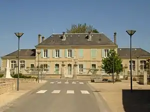 Rathaus (Mairie) von Aubigné | ||

Geographie
Aubigné liegt etwa 41 Kilometer südöstlich von Niort. Umgeben wird Aubigné von den Nachbargemeinden Paizay-le-Chapt im Norden und Nordwesten, Crézières im Norden, La Bataille im Norden und Nordosten, Loubigné im Osten und Nordosten, Loubillé im Osten, Villemain im Osten und Südosten, Villiers-Couture und Romazières im Süden, Saleignes im Südwesten sowie Vinax im Westen und Südwesten.
Bevölkerungsentwicklung
| Jahr | 1962 | 1968 | 1975 | 1982 | 1990 | 1999 | 2006 | 2013 |
| Einwohner | 393 | 336 | 319 | 303 | 248 | 214 | 211 | 212 |
| Quelle: Cassini und INSEE | ||||||||
Sehenswürdigkeiten
- Kirche Saint-Cybard

Kirche Saint-Cybard
This article is issued from Wikipedia. The text is licensed under Creative Commons - Attribution - Sharealike. The authors of the article are listed here. Additional terms may apply for the media files, click on images to show image meta data.