Moriviller
| Moriviller | ||
|---|---|---|
|
| |
| Staat | Frankreich | |
| Region | Grand Est | |
| Département (Nr.) | Meurthe-et-Moselle (54) | |
| Arrondissement | Lunéville | |
| Kanton | Lunéville-2 | |
| Gemeindeverband | Meurthe Mortagne Moselle | |
| Koordinaten | 48° 29′ N, 6° 27′ O | |
| Höhe | 248–344 m | |
| Fläche | 7,26 km² | |
| Einwohner | 92 (1. Januar 2019) | |
| Bevölkerungsdichte | 13 Einw./km² | |
| Postleitzahl | 54830 | |
| INSEE-Code | 54386 | |
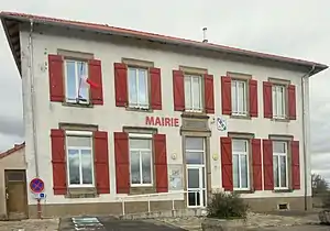 Mairie Moriviller | ||

Moriviller ist eine Gemeinde im französischen Département Meurthe-et-Moselle in der Verwaltungsregion Grand Est. Sie gehört zum Kanton Lunéville-2 und zum Arrondissement Lunéville.
Nachbargemeinden sind Franconville im Norden, Gerbéviller im Osten, Remenoville im Südosten, Rozelieures im Süden, Clayeures im Südwesten sowie Landécourt im Nordwesten.
Bevölkerungsentwicklung
| Jahr | 1962 | 1968 | 1975 | 1982 | 1990 | 1999 | 2008 | 2019 |
|---|---|---|---|---|---|---|---|---|
| Einwohner | 136 | 124 | 104 | 107 | 96 | 81 | 90 | 92 |
 Himmelfahrtskirche
 Marienstatue und Wegkreuz
This article is issued from Wikipedia. The text is licensed under Creative Commons - Attribution - Sharealike. The authors of the article are listed here. Additional terms may apply for the media files, click on images to show image meta data.