Montagny (Rhône)
| Montagny | ||
|---|---|---|
.svg.png.webp)
|
| |
| Staat | Frankreich | |
| Region | Auvergne-Rhône-Alpes | |
| Département (Nr.) | Rhône (69) | |
| Arrondissement | Lyon | |
| Kanton | Saint-Symphorien-d’Ozon | |
| Gemeindeverband | Vallée du Garon | |
| Koordinaten | 45° 38′ N, 4° 45′ O | |
| Höhe | 163–338 m | |
| Fläche | 8,15 km² | |
| Einwohner | 3.118 (1. Januar 2019) | |
| Bevölkerungsdichte | 383 Einw./km² | |
| Postleitzahl | 69700 | |
| INSEE-Code | 69136 | |
| Website | www.montagny69.org | |

Montagny ist eine französische Gemeinde im Département Rhône in der Region Auvergne-Rhône-Alpes. Sie gehört zum Arrondissement Lyon und ist Teil des Kantons Saint-Symphorien-d’Ozon (bis 2015: Kanton Givors). Montagny hat 3118 Einwohner (Stand: 1. Januar 2019).
Geographie
Montagny liegt etwa 16 Kilometer südsüdwestlich von Lyon am Fluss Garon. Umgeben wird Montagny von den Nachbargemeinden Vourles im Norden und Nordosten, Millery im Osten, Grigny im Südosten, Givors im Süden, Beauvallon im Südwesten sowie Taluyers im Nordwesten.
Montagny gehört zum Weinbaugebiet Coteaux du Lyonnais.
Bevölkerungsentwicklung
| Jahr | 1962 | 1968 | 1975 | 1982 | 1990 | 1999 | 2006 | 2012 |
|---|---|---|---|---|---|---|---|---|
| Einwohner | 703 | 762 | 1.227 | 1.803 | 2.202 | 2.322 | 2.377 | 2.604 |
| Quellen: Cassini und INSEE | ||||||||
Sehenswürdigkeiten
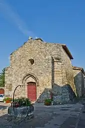
- Kirche aus dem 12. Jahrhundert
- Reste des Schlosses Montagny aus dem 12. Jahrhundert, 1561 zerstört, seitdem Ruine
This article is issued from Wikipedia. The text is licensed under Creative Commons - Attribution - Sharealike. The authors of the article are listed here. Additional terms may apply for the media files, click on images to show image meta data.