Mesnil-Domqueur
Mesnil-Domqueur (picardisch: Au Mouni-Dontcheur) ist eine nordfranzösische Gemeinde mit 89 Einwohnern (Stand 1. Januar 2019) im Département Somme in der Region Hauts-de-France. Die Gemeinde liegt im Arrondissement Abbeville und ist Teil der Communauté de communes Ponthieu-Marquenterre und des Kantons Rue.
| Mesnil-Domqueur | ||
|---|---|---|
| ||
| Staat | Frankreich | |
| Region | Hauts-de-France | |
| Département (Nr.) | Somme (80) | |
| Arrondissement | Abbeville | |
| Kanton | Rue | |
| Gemeindeverband | Ponthieu-Marquenterre | |
| Koordinaten | 50° 8′ N, 2° 4′ O | |
| Höhe | 98–134 m | |
| Fläche | 3,56 km² | |
| Einwohner | 89 (1. Januar 2019) | |
| Bevölkerungsdichte | 25 Einw./km² | |
| Postleitzahl | 80620 | |
| INSEE-Code | 80537 | |
.JPG.webp) Kirche Saint-Sulpice | ||

Geographie
Die Gemeinde liegt rund neun Kilometer nordöstlich von Ailly-le-Haut-Clocher und acht Kilometer westlich von Bernaville. Zur Gemeinde gehört das Gehöft Ferme du Moulin. Das Gemeindegebiet liegt im Regionalen Naturpark Baie de Somme Picardie Maritime.
Einwohner
| 1962 | 1968 | 1975 | 1982 | 1990 | 1999 | 2006 | 2011 |
|---|---|---|---|---|---|---|---|
| 92 | 86 | 70 | 81 | 79 | 57 | 80 | 91 |
Sehenswürdigkeiten
- Kirche Saint-Sulpice[1]
- Souterrains (muches)
- Kriegerdenkmal
.JPG.webp) Zugang zum Souterrain in der Kirche
Zugang zum Souterrain in der Kirche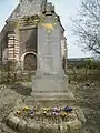 Kriegerdenkmal
Weblinks
Commons: Mesnil-Domqueur – Sammlung von Bildern, Videos und Audiodateien
This article is issued from Wikipedia. The text is licensed under Creative Commons - Attribution - Sharealike. The authors of the article are listed here. Additional terms may apply for the media files, click on images to show image meta data.