Kanton Rue
Der Kanton Rue ist ein französischer Kanton im Arrondissement Abbeville, im Département Somme und in der Region Hauts-de-France; sein Hauptort ist Rue. Vertreter im Generalrat des Départements ist seit 2004 Jean-Louis Wadoux (UMP).
| Kanton Rue | |
|---|---|
| Region | Hauts-de-France |
| Département | Somme |
| Arrondissement | Abbeville |
| Hauptort | Rue |
| Einwohner | 24.827 (1. Jan. 2019) |
| Bevölkerungsdichte | 40 Einw./km² |
| Fläche | 619,78 km² |
| Gemeinden | 55 |
| INSEE-Code | 8023 |
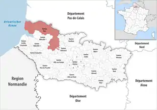 Lage des Kantons Rue im Département Somme | |
Gemeinden
Der Kanton besteht aus 55 Gemeinden mit insgesamt 24.827 Einwohnern (Stand: 1. Januar 2019) auf einer Gesamtfläche von 619,78 km²:
| Gemeinde | Einwohner 1. Januar 2019 |
Fläche km² |
Dichte Einw./km² |
Code INSEE |
Postleitzahl |
|---|---|---|---|---|---|
| Ailly-le-Haut-Clocher | 997 | 10,85 | 92 | 80009 | 80690 |
| Argoules | 327 | 9,53 | 34 | 80025 | 80120 |
| Arry | 216 | 7,43 | 29 | 80030 | 80120 |
| Bernay-en-Ponthieu | 238 | 9,94 | 24 | 80087 | 80120 |
| Boufflers | 116 | 5,58 | 21 | 80118 | 80150 |
| Brailly-Cornehotte | 238 | 11,56 | 21 | 80133 | 80150 |
| Brucamps | 138 | 6,43 | 21 | 80145 | 80690 |
| Buigny-l’Abbé | 326 | 7,32 | 45 | 80147 | 80132 |
| Bussus-Bussuel | 293 | 8,29 | 35 | 80155 | 80135 |
| Cocquerel | 223 | 9,58 | 23 | 80200 | 80510 |
| Coulonvillers | 220 | 9,60 | 23 | 80215 | 80135 |
| Cramont | 305 | 9,75 | 31 | 80221 | 80370 |
| Crécy-en-Ponthieu | 1.370 | 57,43 | 24 | 80222 | 80150 |
| Dominois | 174 | 6,22 | 28 | 80244 | 80120 |
| Dompierre-sur-Authie | 418 | 22,78 | 18 | 80248 | 80150 |
| Domqueur | 312 | 8,49 | 37 | 80249 | 80620 |
| Ergnies | 176 | 1,99 | 88 | 80281 | 80690 |
| Estrées-lès-Crécy | 391 | 11,22 | 35 | 80290 | 80150 |
| Favières | 462 | 12,74 | 36 | 80303 | 80120 |
| Fontaine-sur-Maye | 158 | 5,73 | 28 | 80327 | 80150 |
| Fort-Mahon-Plage | 1.298 | 13,35 | 97 | 80333 | 80120 |
| Francières | 182 | 5,87 | 31 | 80344 | 80690 |
| Froyelles | 97 | 2,79 | 35 | 80371 | 80150 |
| Gorenflos | 243 | 6,27 | 39 | 80380 | 80690 |
| Gueschart | 361 | 12,97 | 28 | 80396 | 80150 |
| Le Boisle | 343 | 11,73 | 29 | 80109 | 80150 |
| Le Crotoy | 1.989 | 16,68 | 119 | 80228 | 80550 |
| Ligescourt | 222 | 5,17 | 43 | 80477 | 80150 |
| Long | 618 | 9,35 | 66 | 80486 | 80510 |
| Machiel | 154 | 6,55 | 24 | 80496 | 80150 |
| Machy | 118 | 3,29 | 36 | 80497 | 80150 |
| Maison-Ponthieu | 283 | 11,01 | 26 | 80501 | 80150 |
| Maison-Roland | 101 | 5,03 | 20 | 80502 | 80135 |
| Mesnil-Domqueur | 89 | 3,56 | 25 | 80537 | 80620 |
| Mouflers | 95 | 3,56 | 27 | 80574 | 80690 |
| Nampont | 250 | 19,53 | 13 | 80580 | 80120 |
| Neuilly-le-Dien | 100 | 4,93 | 20 | 80589 | 80150 |
| Noyelles-en-Chaussée | 241 | 10,57 | 23 | 80599 | 80150 |
| Oneux | 408 | 12,54 | 33 | 80609 | 80135 |
| Ponches-Estruval | 98 | 7,18 | 14 | 80631 | 80150 |
| Pont-Remy | 1.459 | 10,08 | 145 | 80635 | 80580 |
| Quend | 1.313 | 37,48 | 35 | 80649 | 80120 |
| Regnière-Écluse | 123 | 9,65 | 13 | 80665 | 80120 |
| Rue | 3.111 | 29,45 | 106 | 80688 | 80120 |
| Saint-Quentin-en-Tourmont | 281 | 26,30 | 11 | 80713 | 80120 |
| Saint-Riquier | 1.265 | 14,82 | 85 | 80716 | 80135 |
| Vercourt | 95 | 4,74 | 20 | 80787 | 80120 |
| Villers-sous-Ailly | 179 | 6,36 | 28 | 80804 | 80690 |
| Villers-sur-Authie | 471 | 12,26 | 38 | 80806 | 80120 |
| Vironchaux | 498 | 16,26 | 31 | 80808 | 80150 |
| Vitz-sur-Authie | 135 | 4,72 | 29 | 80810 | 80150 |
| Vron | 836 | 20,70 | 40 | 80815 | 80120 |
| Yaucourt-Bussus | 245 | 7,13 | 34 | 80830 | 80135 |
| Yvrench | 305 | 9,37 | 33 | 80832 | 80150 |
| Yvrencheux | 123 | 6,07 | 20 | 80833 | 80150 |
| Kanton Rue | 24.827 | 619,78 | 40 | 8023 | – |
Bis zur Neuordnung bestand der Kanton Rue aus den 17 Gemeinden Argoules, Arry, Bernay-en-Ponthieu, Le Crotoy, Favières, Fort-Mahon-Plage, Machiel, Machy, Nampont, Quend, Regnière-Écluse, Rue, Saint-Quentin-en-Tourmont, Vercourt, Villers-sur-Authie, Vironchaux und Vron. Sein Zuschnitt entsprach einer Fläche von 206,79 km2.
Weblinks
This article is issued from Wikipedia. The text is licensed under Creative Commons - Attribution - Sharealike. The authors of the article are listed here. Additional terms may apply for the media files, click on images to show image meta data.