Huppy
Huppy ist eine französische Gemeinde mit 755 Einwohnern (Stand 1. Januar 2019) im Département Somme in der Region Hauts-de-France. Sie gehört zum Arrondissement Abbeville und zum Kanton Gamaches.
| Huppy | ||
|---|---|---|

|
| |
| Staat | Frankreich | |
| Region | Hauts-de-France | |
| Département (Nr.) | Somme (80) | |
| Arrondissement | Abbeville | |
| Kanton | Gamaches | |
| Gemeindeverband | Baie de Somme | |
| Koordinaten | 50° 2′ N, 1° 46′ O | |
| Höhe | 60–113 m | |
| Fläche | 10,76 km² | |
| Einwohner | 755 (1. Januar 2019) | |
| Bevölkerungsdichte | 70 Einw./km² | |
| Postleitzahl | 80140 | |
| INSEE-Code | 80446 | |
| Website | http://www.huppy.net | |
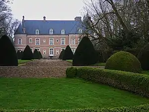 Schloss Huppy | ||

Geographie
Huppy liegt auf der Kalkhochfläche des Vimeu zwischen den Départementsstraßen D928 (frühere Route nationale 28) von Abbeville nach Blangy-sur-Bresle und D25 und wird im Westen von der Autoroute A28 durchquert. Das Gemeindegebiet liegt im Regionalen Naturpark Baie de Somme Picardie Maritime.
Geschichte
Das Schloss wurde 1692 fertiggestellt.
Einwohner
| 1962 | 1968 | 1975 | 1982 | 1990 | 1999 | 2006 | 2011 |
|---|---|---|---|---|---|---|---|
| 614 | 631 | 579 | 592 | 590 | 694 | 761 | 805 |
Sehenswürdigkeiten

Kirche Saint-Sulpice
- Schloss Huppy (17. Jahrhundert), Kommandozentrale Charles de Gaulles während der Schlacht von Abbeville (28.–31. Mai 1940), 1926 als Monument historique eingetragen (Base Mérimée PA00116182)[1]
- 1907 als Monument historique klassifizierte Kirche Saint-Sulpice (Base Mérimée PA00116184)[2]
- steinernes Kreuz aus dem 13. Jahrhundert, 1912 als Monument historique klassifiziert[3]
Weblinks
Commons: Huppy – Sammlung von Bildern, Videos und Audiodateien
This article is issued from Wikipedia. The text is licensed under Creative Commons - Attribution - Sharealike. The authors of the article are listed here. Additional terms may apply for the media files, click on images to show image meta data.