Brucamps
Brucamps (picardisch: Brucamp) ist eine nordfranzösische Gemeinde mit 138 Einwohnern (Stand 1. Januar 2019) im Département Somme in der Region Hauts-de-France. Die Gemeinde liegt im Arrondissement Abbeville und ist Teil der Communauté de communes Ponthieu-Marquenterre und des Kantons Rue.
| Brucamps | ||
|---|---|---|
.svg.png.webp)
|
| |
| Staat | Frankreich | |
| Region | Hauts-de-France | |
| Département (Nr.) | Somme (80) | |
| Arrondissement | Abbeville | |
| Kanton | Rue | |
| Gemeindeverband | Ponthieu-Marquenterre | |
| Koordinaten | 50° 4′ N, 2° 3′ O | |
| Höhe | 54–115 m | |
| Fläche | 6,43 km² | |
| Einwohner | 138 (1. Januar 2019) | |
| Bevölkerungsdichte | 21 Einw./km² | |
| Postleitzahl | 80690 | |
| INSEE-Code | 80145 | |
 Einfahrt zu einem Gehöft | ||

Geographie
Die Gemeinde liegt rund 4,5 km östlich von Ailly-le-Haut-Clocher und 6 km westlich von Domart-en-Ponthieu.
Einwohner
| 1962 | 1968 | 1975 | 1982 | 1990 | 1999 | 2006 | 2011 |
|---|---|---|---|---|---|---|---|
| 161 | 159 | 133 | 124 | 121 | 109 | 134 | 142 |
Sehenswürdigkeiten
- 1902 errichtete Kirche Saint-Martin[1]
- Kriegerdenkmal
- frühere Gemeindeschule mit Glockenstuhl
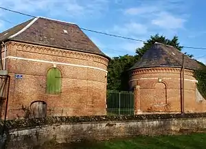
- mehrere imposante Gehöfte und Taubenhäuser
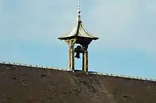
Glockenstuhl an der früheren Gemeindeschule
Taubenhaus
Weblinks
Commons: Brucamps – Sammlung von Bildern, Videos und Audiodateien
This article is issued from Wikipedia. The text is licensed under Creative Commons - Attribution - Sharealike. The authors of the article are listed here. Additional terms may apply for the media files, click on images to show image meta data.