Menou
Menou ist eine französische Gemeinde mit 185 Einwohnern (Stand 1. Januar 2019) im Département Nièvre in der Region Bourgogne-Franche-Comté (vor 2016 Bourgogne). Sie gehört zum Arrondissement Clamecy und zum Kanton Clamecy (bis 2015 Varzy). Die Einwohner werden Nantinivinois genannt.
| Menou | ||
|---|---|---|
| ||
| Staat | Frankreich | |
| Region | Bourgogne-Franche-Comté | |
| Département (Nr.) | Nièvre (58) | |
| Arrondissement | Clamecy | |
| Kanton | Clamecy | |
| Gemeindeverband | Haut Nivernais-Val d’Yonne | |
| Koordinaten | 47° 22′ N, 3° 17′ O | |
| Höhe | 179–362 m | |
| Fläche | 17,55 km² | |
| Einwohner | 185 (1. Januar 2019) | |
| Bevölkerungsdichte | 11 Einw./km² | |
| Postleitzahl | 58210 (früher: 58630) | |
| INSEE-Code | 58163 | |
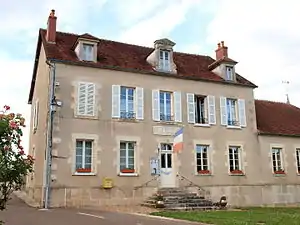 Rathaus (Mairie) von Menou | ||

Geographie
Menou liegt etwa 50 Kilometer nordnordöstlich von Nevers. Nachbargemeinden von Menou sind Menestreau im Norden, La Chapelle-Saint-André im Osten und Nordosten, Oudan im Osten und Südosten, Colméry im Süden und Westen sowie Couloutre im Westen und Nordwesten.
Bevölkerungsentwicklung
| Jahr | 1962 | 1968 | 1975 | 1982 | 1990 | 1999 | 2006 | 2011 | 2016 |
| Einwohner | 335 | 293 | 251 | 209 | 201 | 172 | 172 | 182 | 182 |
| Quellen: Cassini und INSEE | |||||||||
Sehenswürdigkeiten
- Kirche Saint-Siméon
- Kapelle Notre-Dame-de-la-Tête-Ronde
- Schloss Menou, 1672 erbaut
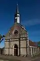 Kirche Saint-Siméon
 Kloster Notre-Dame-de-la-Tête-Ronde
 Schloss Menou
Literatur
- Le Patrimoine des Communes de la Nièvre. Band 2, Flohic Editions, Charenton-le-Pont 1999, ISBN 2-84234-054-X, S. 1052–1054.
Weblinks
Commons: Menou – Sammlung von Bildern, Videos und Audiodateien
This article is issued from Wikipedia. The text is licensed under Creative Commons - Attribution - Sharealike. The authors of the article are listed here. Additional terms may apply for the media files, click on images to show image meta data.