Courcelles (Nièvre)
Courcelles ist eine französische Gemeinde mit 219 Einwohnern (Stand 1. Januar 2019) im Département Nièvre in der Region Bourgogne-Franche-Comté (vor 2016 Bourgogne). Sie gehört zum Arrondissement Clamecy und zum Kanton Clamecy (bis 2015 Varzy).
| Courcelles | ||
|---|---|---|
| ||
| Staat | Frankreich | |
| Region | Bourgogne-Franche-Comté | |
| Département (Nr.) | Nièvre (58) | |
| Arrondissement | Clamecy | |
| Kanton | Clamecy | |
| Gemeindeverband | Haut Nivernais-Val d’Yonne | |
| Koordinaten | 47° 24′ N, 3° 24′ O | |
| Höhe | 181–289 m | |
| Fläche | 9,69 km² | |
| Einwohner | 219 (1. Januar 2019) | |
| Bevölkerungsdichte | 23 Einw./km² | |
| Postleitzahl | 58210 | |
| INSEE-Code | 58090 | |
 Rathaus (Mairie) von Courcelles | ||

Geographie
Courcelles liegt etwa 50 Kilometer südsüdwestlich von Auxerre. Nachbargemeinden von Courcelles sind Corvol-l’Orgueilleux im Norden, Saint-Pierre-du-Mont im Osten, Varzy im Süden sowie La Chapelle-Saint-André im Westen.
Bevölkerungsentwicklung
| Jahr | 1962 | 1968 | 1975 | 1982 | 1990 | 1999 | 2006 | 2011 | 2016 |
| Einwohner | 324 | 301 | 266 | 227 | 254 | 225 | 215 | 208 | 214 |
| Quellen: Cassini und INSEE | |||||||||
Sehenswürdigkeiten
- Kirche Saint-Nicolas
- Mühle von Chivres
- Schloss Bazarnes
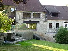
Mühle von Chivres
Persönlichkeiten
- Jacques Alexandre François Allix de Vaux (1768–1836), General, Graf von Freudenthal
Literatur
- Le Patrimoine des Communes de la Nièvre. Band 2, Flohic Editions, Charenton-le-Pont 1999, ISBN 2-84234-054-X, S. 1041–1043.
Weblinks
Commons: Courcelles – Sammlung von Bildern, Videos und Audiodateien
This article is issued from Wikipedia. The text is licensed under Creative Commons - Attribution - Sharealike. The authors of the article are listed here. Additional terms may apply for the media files, click on images to show image meta data.