Brèves
Brèves ist eine französische Gemeinde mit 269 Einwohnern (Stand: 1. Januar 2019) im Département Nièvre in der Region Bourgogne-Franche-Comté. Sie gehört zum Arrondissement Clamecy und zum Kanton Clamecy.
| Brèves | ||
|---|---|---|
| ||
| Staat | Frankreich | |
| Region | Bourgogne-Franche-Comté | |
| Département (Nr.) | Nièvre (58) | |
| Arrondissement | Clamecy | |
| Kanton | Clamecy | |
| Gemeindeverband | Haut Nivernais-Val d’Yonne | |
| Koordinaten | 47° 25′ N, 3° 36′ O | |
| Höhe | 152–309 m | |
| Fläche | 16,63 km² | |
| Einwohner | 236 (1. Januar 2019) | |
| Bevölkerungsdichte | 14 Einw./km² | |
| Postleitzahl | 58530 | |
| INSEE-Code | 58039 | |
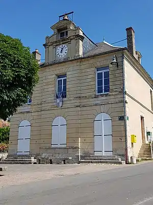 Rathaus (Mairie) von Brèves | ||

Geographie
Brèves liegt etwa 44 Kilometer südsüdöstlich von Auxerre. Die Yonne bildet die südwestliche Gemeindegrenze. Nachbargemeinden von Brèves sind Dornecy im Norden und Nordwesten, Asnières-sous-Bois im Norden, Chamoux im Nordosten, La Maison-Dieu im Osten, Metz-le-Comte und Asnois im Süden sowie Villiers-sur-Yonne im Westen und Südwesten.
Bevölkerungsentwicklung
| Jahr | 1962 | 1968 | 1975 | 1982 | 1990 | 1999 | 2006 | 2018 | |
| Einwohner | 300 | 298 | 273 | 234 | 286 | 308 | 299 | 240 | |
| Quellen: Cassini und INSEE | |||||||||
Sehenswürdigkeiten
- Kirche Saint-Siméon aus dem Jahre 1832
- Schleuse
- Ehemalige Wassermühle
Literatur
- Le Patrimoine des Communes de la Nièvre. Band 1, Flohic Editions, Charenton-le-Pont 1999, ISBN 2-84234-054-X, S. 254–257.
Weblinks
Commons: Brèves (Nièvre) – Sammlung von Bildern, Videos und Audiodateien
This article is issued from Wikipedia. The text is licensed under Creative Commons - Attribution - Sharealike. The authors of the article are listed here. Additional terms may apply for the media files, click on images to show image meta data.