Le Fœil
Le Fœil (bretonisch: Ar Fouilh) ist eine französische Gemeinde mit 1.412 Einwohnern (Stand: 1. Januar 2019) im Département Côtes-d’Armor in der Region Bretagne. Sie gehört administrativ zum Arrondissement Saint-Brieuc.
| Le Fœil Ar Fouilh | ||
|---|---|---|
| ||
| Staat | Frankreich | |
| Region | Bretagne | |
| Département (Nr.) | Côtes-d’Armor (22) | |
| Arrondissement | Saint-Brieuc | |
| Kanton | Plélo | |
| Gemeindeverband | Saint-Brieuc Armor Agglomération | |
| Koordinaten | 48° 26′ N, 2° 55′ W | |
| Höhe | 129–256 m | |
| Fläche | 21,82 km² | |
| Einwohner | 1.412 (1. Januar 2019) | |
| Bevölkerungsdichte | 65 Einw./km² | |
| Postleitzahl | 22800 | |
| INSEE-Code | 22059 | |
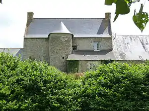 Herrenhaus in Le Fœil | ||

Geographie
Die Gemeinde liegt etwa 25 Kilometer von der Meeresküste entfernt. Umgeben wird Le Fœil von der Gemeinde Cohiniac im Norden, von Plaine-Haute im Osten, von Quintin im Süden und von Le Leslay im Westen.
Bevölkerungsentwicklung
| 1962 | 1968 | 1975 | 1982 | 1990 | 1999 | 2008 | 2012 |
| 857 | 884 | 888 | 1.084 | 1.085 | 1.124 | 1.405 | 1.509 |
Baudenkmäler
Literatur
- Le Patrimoine des Communes des Côtes-d’Armor. Flohic Editions, Band 2, Paris 1998, ISBN 2-84234-017-5, S. 1109–1112.
Weblinks
Commons: Le Fœil – Sammlung von Bildern, Videos und Audiodateien
This article is issued from Wikipedia. The text is licensed under Creative Commons - Attribution - Sharealike. The authors of the article are listed here. Additional terms may apply for the media files, click on images to show image meta data.