Lamaguère
Lamaguère ist eine französische Gemeinde mit 80 Einwohnern (Stand 1. Januar 2019) im Département Gers in der Region Okzitanien. Sie gehört zum Arrondissement Mirande und zum Kanton Astarac-Gimone.
| Lamaguère | ||
|---|---|---|
| ||
| Staat | Frankreich | |
| Region | Okzitanien | |
| Département (Nr.) | Gers (32) | |
| Arrondissement | Mirande | |
| Kanton | Astarac-Gimone | |
| Gemeindeverband | Communauté de communes Val de Gers | |
| Koordinaten | 43° 30′ N, 0° 40′ O | |
| Höhe | 191–297 m | |
| Fläche | 6,67 km² | |
| Einwohner | 80 (1. Januar 2019) | |
| Bevölkerungsdichte | 12 Einw./km² | |
| Postleitzahl | 32260 | |
| INSEE-Code | 32186 | |

Nachbargemeinden sind Faget-Abbatial im Norden, Simorre im Osten, Tachoires im Süden und Monferran-Plavès im Westen.
Bevölkerungsentwicklung
| Jahr | 1962 | 1968 | 1975 | 1982 | 1990 | 1999 | 2008 | 2016 |
|---|---|---|---|---|---|---|---|---|
| Einwohner | 100 | 96 | 82 | 92 | 79 | 66 | 63 | 81 |
| Quellen: Cassini und INSEE | ||||||||
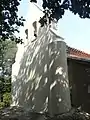 Kapelle Libou
 Kirche Saint-Michel, Monument historique seit 1974
Weblinks
Commons: Lamaguère – Sammlung von Bildern, Videos und Audiodateien
This article is issued from Wikipedia. The text is licensed under Creative Commons - Attribution - Sharealike. The authors of the article are listed here. Additional terms may apply for the media files, click on images to show image meta data.