Husseren-Wesserling
Husseren-Wesserling (dt. Hüsseren-Wesserling) ist eine französische Gemeinde mit 1048 Einwohnern (Stand 1. Januar 2019) im Département Haut-Rhin in der Region Grand Est (bis 2015 Elsass). Sie gehört zum Arrondissement Thann-Guebwiller, zum Kanton Cernay und zum Kommunalverband Vallée de Saint-Amarin.
| Husseren-Wesserling | ||
|---|---|---|
.svg.png.webp)
|
| |
| Staat | Frankreich | |
| Region | Grand Est | |
| Département (Nr.) | Haut-Rhin (68) | |
| Arrondissement | Thann-Guebwiller | |
| Kanton | Cernay | |
| Gemeindeverband | Vallée de Saint-Amarin | |
| Koordinaten | 47° 53′ N, 6° 59′ O | |
| Höhe | 415–840 m | |
| Fläche | 5,31 km² | |
| Einwohner | 1.048 (1. Januar 2019) | |
| Bevölkerungsdichte | 197 Einw./km² | |
| Postleitzahl | 68470 | |
| INSEE-Code | 68151 | |
| Website | http://www.husseren-wesserling.fr/ | |
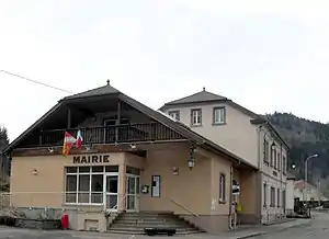 Mairie Husseren-Wesserling | ||

Geografie
Die Gemeinde liegt im oberen Thurtal in den Vogesen nahe dem Col de Bussang. Das Gemeindegebiet ist Teil des Regionalen Naturparks Ballons des Vosges.
Bevölkerungsentwicklung
| Jahr | 1962 | 1968 | 1975 | 1982 | 1990 | 1999 | 2007 | 2018 |
| Einwohner | 1100 | 1130 | 1023 | 947 | 919 | 971 | 1011 | 1048 |
 Kirche Saints-Philippe-et-Jacques
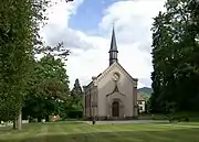 ehemalige Protestantische Kirche aus dem Jahr 1854
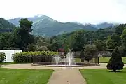 Garten im Park Wesserling
Literatur
- Le Patrimoine des Communes du Haut-Rhin. Flohic Editions, Band 2, Paris 1998, ISBN 2-84234-036-1, S. 1047.
Weblinks
Commons: Husseren-Wesserling – Sammlung von Bildern, Videos und Audiodateien
- Gemeindepräsentation (französisch)
This article is issued from Wikipedia. The text is licensed under Creative Commons - Attribution - Sharealike. The authors of the article are listed here. Additional terms may apply for the media files, click on images to show image meta data.