Geishouse
Geishouse (dt. Geishausen) ist eine französische Gemeinde mit 439 Einwohnern (Stand 1. Januar 2019) im Département Haut-Rhin in der Region Grand Est (bis 2015 Elsass). Sie gehört zum Arrondissement Thann-Guebwiller, zum Kanton Cernay und zum Gemeindeverband Vallée de Saint-Amarin.
| Geishouse | ||
|---|---|---|
.svg.png.webp)
|
| |
| Staat | Frankreich | |
| Region | Grand Est | |
| Département (Nr.) | Haut-Rhin (68) | |
| Arrondissement | Thann-Guebwiller | |
| Kanton | Cernay | |
| Gemeindeverband | Vallée de Saint-Amarin | |
| Koordinaten | 47° 53′ N, 7° 4′ O | |
| Höhe | 510–1422 m | |
| Fläche | 7,19 km² | |
| Einwohner | 439 (1. Januar 2019) | |
| Bevölkerungsdichte | 61 Einw./km² | |
| Postleitzahl | 68690 | |
| INSEE-Code | 68102 | |
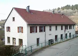 Rathaus- und Schulgebäude | ||

Geografie

Blick auf Geishouse
Das Gemeindegebiet umfasst 7,28 Quadratkilometer und liegt am Fuß des Grand Ballon, des mit 1424 Metern höchsten Vogesengipfels im Regionalen Naturpark Ballons des Vosges.
Bevölkerungsentwicklung
| Jahr | 1962 | 1968 | 1975 | 1982 | 1990 | 1999 | 2007 | 2017 |
| Einwohner | 383 | 402 | 352 | 376 | 423 | 472 | 481 | 441 |
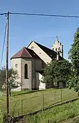
- Kirche Saint-Sébastien

Literatur
- Le Patrimoine des Communes du Haut-Rhin. Flohic Editions, Band 2, Paris 1998, ISBN 2-84234-036-1, S. 1042–1044.
This article is issued from Wikipedia. The text is licensed under Creative Commons - Attribution - Sharealike. The authors of the article are listed here. Additional terms may apply for the media files, click on images to show image meta data.