Roderen
Roderen (deutsch Rodern) ist eine französische Gemeinde mit 902 Einwohnern (Stand 1. Januar 2019) im Département Haut-Rhin in der Region Grand Est (bis 2015 Elsass).
| Roderen | ||
|---|---|---|
.svg.png.webp)
|
| |
| Staat | Frankreich | |
| Region | Grand Est | |
| Département (Nr.) | Haut-Rhin (68) | |
| Arrondissement | Thann-Guebwiller | |
| Kanton | Cernay | |
| Gemeindeverband | Thann-Cernay | |
| Koordinaten | 47° 47′ N, 7° 6′ O | |
| Höhe | 327–514 m | |
| Fläche | 7,18 km² | |
| Einwohner | 902 (1. Januar 2019) | |
| Bevölkerungsdichte | 126 Einw./km² | |
| Postleitzahl | 68800 | |
| INSEE-Code | 68279 | |
| Website | http://www.roderen.fr | |
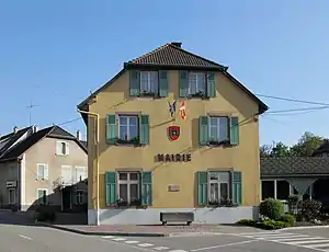 Rathaus | ||

Geografie
Die Gemeinde Roderen liegt im Regionalen Naturpark Ballons des Vosges, 20 Kilometer westlich von Mülhausen am Fuß der Vogesen.
Bevölkerungsentwicklung
| Jahr | 1962 | 1968 | 1975 | 1982 | 1990 | 1999 | 2007 | 2016 |
| Einwohner | 631 | 644 | 682 | 769 | 817 | 863 | 867 | 893 |
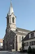 Kirche Saint-Laurent
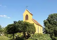 Kapelle Maria auf dem Rain
Siehe auch
Literatur
- Le Patrimoine des Communes du Haut-Rhin. Flohic Editions, Band 2, Paris 1998, ISBN 2-84234-036-1, S. 1275–1277.
Weblinks
Commons: Roderen – Sammlung von Bildern, Videos und Audiodateien
- Roderen auf ccpaysdethann.fr (französisch)
This article is issued from Wikipedia. The text is licensed under Creative Commons - Attribution - Sharealike. The authors of the article are listed here. Additional terms may apply for the media files, click on images to show image meta data.