Villiers-Couture
Villiers-Couture ist eine französische Gemeinde mit 110 Einwohnern (Stand: 1. Januar 2019) im Département Charente-Maritime in der Region Nouvelle-Aquitaine (vor 2016: Poitou-Charentes); sie gehört zum Arrondissement Saint-Jean-d’Angély und ist Teil des Kantons Matha (bis 2015: Kanton Aulnay). Die Einwohner werden Villiérois genannt.
| Villiers-Couture | ||
|---|---|---|
| ||
| Staat | Frankreich | |
| Region | Nouvelle-Aquitaine | |
| Département (Nr.) | Charente-Maritime (17) | |
| Arrondissement | Saint-Jean-d’Angély | |
| Kanton | Matha | |
| Gemeindeverband | Vals de Saintonge | |
| Koordinaten | 45° 59′ N, 0° 9′ W | |
| Höhe | 96–138 m | |
| Fläche | 8,46 km² | |
| Einwohner | 110 (1. Januar 2019) | |
| Bevölkerungsdichte | 13 Einw./km² | |
| Postleitzahl | 17510 | |
| INSEE-Code | 17477 | |

Geographie
Villiers-Couture liegt etwa 75 Kilometer ostsüdöstlich von La Rochelle in der Saintonge. Umgeben wird Villiers-Couture von den Nachbargemeinden Aubigné im Norden, Villemain im Nordosten, Couture-d’Argenson im Osten, Chives im Südosten, Fontaine-Chalendray im Süden sowie Romazières im Westen.
Bevölkerungsentwicklung
| Jahr | 1962 | 1968 | 1975 | 1982 | 1990 | 1999 | 2006 | 2013 |
| Einwohner | 187 | 171 | 151 | 171 | 163 | 168 | 156 | 128 |
| Quelle: Cassini und INSEE | ||||||||
Sehenswürdigkeiten
Siehe auch: Liste der Monuments historiques in Villiers-Couture
- Kirche Saint-Hilaire aus dem 11. Jahrhundert, seit 1969 Monument historique
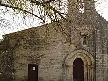
Kirche Saint-Hilaire
Literatur
- Le Patrimoine des Communes de la Charente-Maritime. Flohic Editions, Band 1, Paris 2002, ISBN 2-84234-129-5, S. 148–150.
This article is issued from Wikipedia. The text is licensed under Creative Commons - Attribution - Sharealike. The authors of the article are listed here. Additional terms may apply for the media files, click on images to show image meta data.