Saint-Vite
Saint-Vite ist eine Gemeinde mit 1.163 Einwohnern (Stand: 1. Januar 2019) in Frankreich im Département Lot-et-Garonne in der Region Nouvelle-Aquitaine (vor 2016: Aquitanien). Saint-Vite gehört zum Arrondissement Villeneuve-sur-Lot und zum Kanton Le Fumélois (bis 2015: Kanton Tournon-d’Agenais). Die Einwohner werden Saint-Vitois genannt.
| Saint-Vite | ||
|---|---|---|
| ||
| Staat | Frankreich | |
| Region | Nouvelle-Aquitaine | |
| Département (Nr.) | Lot-et-Garonne (47) | |
| Arrondissement | Villeneuve-sur-Lot | |
| Kanton | Le Fumélois | |
| Gemeindeverband | Fumel Vallée du Lot | |
| Koordinaten | 44° 28′ N, 0° 56′ O | |
| Höhe | 57–105 m | |
| Fläche | 5,52 km² | |
| Einwohner | 1.163 (1. Januar 2019) | |
| Bevölkerungsdichte | 211 Einw./km² | |
| Postleitzahl | 47500 | |
| INSEE-Code | 47283 | |
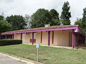 Rathaus (Mairie) von Saint-Vite | ||

Geografie
Der Fluss Lot bildet die nördliche Grenze der Gemeinde Saint-Vite. Umgeben wird Saint-Vite von den Nachbargemeinden Condezaygues im Norden und Westen, Monsempron-Libos im Norden, Fumel im Nordosten, Montayral im Osten, Saint-Georges im Süden sowie Trentels im Südwesten.
Bevölkerungsentwicklung
| 1962 | 1968 | 1975 | 1982 | 1990 | 1999 | 2006 | 2017 |
|---|---|---|---|---|---|---|---|
| 802 | 844 | 1358 | 1442 | 1421 | 1231 | 1181 | 1170 |
| Quellen: Cassini und INSEE | |||||||
Sehenswürdigkeiten
- Kirche Saint-Vite
- Schloss Lapoujade aus dem 16. Jahrhundert, seit 2007 Monument historique
- Schloss Les Rochers
- Mühle
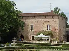
Schloss Lapoujade
This article is issued from Wikipedia. The text is licensed under Creative Commons - Attribution - Sharealike. The authors of the article are listed here. Additional terms may apply for the media files, click on images to show image meta data.