Saint-Pastour
Saint-Pastour (okzitanisch: Sant Pastor) ist eine französische Stadt mit 377 Einwohnern (Stand: 1. Januar 2019) im Département Lot-et-Garonne in der Region Nouvelle-Aquitaine. Die Gemeinde liegt im Arrondissement Villeneuve-sur-Lot und ist Teil des Kantons Le Livradais.
| Saint-Pastour Sant Pastor | ||
|---|---|---|

|
| |
| Staat | Frankreich | |
| Region | Nouvelle-Aquitaine | |
| Département (Nr.) | Lot-et-Garonne (47) | |
| Arrondissement | Villeneuve-sur-Lot | |
| Kanton | Le Livradais | |
| Gemeindeverband | Lot et Tolzac | |
| Koordinaten | 44° 29′ N, 0° 36′ O | |
| Höhe | 62–196 m | |
| Fläche | 14,62 km² | |
| Einwohner | 377 (1. Januar 2019) | |
| Bevölkerungsdichte | 26 Einw./km² | |
| Postleitzahl | 47290 | |
| INSEE-Code | 47265 | |
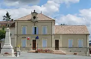
 Rathaus (Mairie) von Saint-Pastour | ||
Geographie
Saint-Pastour liegt etwa 31 Kilometer nördlich von Agen. Saint-Pastour wird umgeben von den Nachbargemeinden Beaugas im Norden, Pailloles im Osten, Casseneuil im Süden sowie Pinel-Hauterive im Westen.
Geschichte
Saint-Pastour wurde als Bastide 1259 von Alfons von Poitiers gegründet.
Bevölkerungsentwicklung
| 1962 | 1968 | 1975 | 1982 | 1990 | 1999 | 2006 | 2018 |
|---|---|---|---|---|---|---|---|
| 444 | 429 | 338 | 343 | 347 | 361 | 381 | 382 |
| Quellen: Cassini und INSEE | |||||||
Sehenswürdigkeiten
- Kirche Saint-Pastour aus dem 15. Jahrhundert, seit 1926 Monument historique
- Kirche Saint-Jean in Aigues-Vives aus dem 11. Jahrhundert
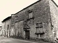
- Herrenhaus Cabirol aus dem 16. Jahrhundert, Monument historique
- Burgruine Saint-Pastour, Monument historique
- Markthalle, Monument historique
- Ortsbefestigung
 Kirche Saint-Pastour
 Kirche Saint-Jean
 Herrenhaus Cabirol
 Burgruine Saint-Pastour
 ehemalige Markthalle
This article is issued from Wikipedia. The text is licensed under Creative Commons - Attribution - Sharealike. The authors of the article are listed here. Additional terms may apply for the media files, click on images to show image meta data.
