Castillonnès
Castillonnès (okzitanisch: Castilhones) ist eine französische Gemeinde mit 1.370 Einwohnern (Stand: 1. Januar 2019) im Département Lot-et-Garonne in der Region Nouvelle-Aquitaine. Sie gehört zum Arrondissement Villeneuve-sur-Lot und zum Kanton Le Val du Dropt (bis 2015: Kanton Castillonnès). Die Einwohner werden Castillonnésiens genannt.
| Castillonnès Castilhones | ||
|---|---|---|
.svg.png.webp)
|
| |
| Staat | Frankreich | |
| Region | Nouvelle-Aquitaine | |
| Département (Nr.) | Lot-et-Garonne (47) | |
| Arrondissement | Villeneuve-sur-Lot | |
| Kanton | Le Val du Dropt | |
| Gemeindeverband | Bastides en Haut Agenais Périgord | |
| Koordinaten | 44° 39′ N, 0° 36′ O | |
| Höhe | 62–145 m | |
| Fläche | 19,41 km² | |
| Einwohner | 1.370 (1. Januar 2019) | |
| Bevölkerungsdichte | 71 Einw./km² | |
| Postleitzahl | 47330 | |
| INSEE-Code | 47057 | |
| Website | http://www.mairie-castillonnes.fr/ | |
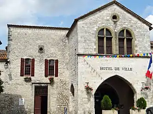 Rathaus (Hotel de ville) von Castillonnès | ||

Geographie
Castillonnès liegt etwa 24 Kilometer südsüdöstlich von Bergerac. Der Dropt begrenzt die Gemeinde im Norden. Umgeben wird Castillonnès von den Nachbargemeinden Saint-Quentin-du-Dropt im Norden, Ferrensac im Osten, Lougratte im Süden, Montauriol im Westen und Südwesten, Douzains im Westen sowie Cahuzac im Nordwesten.
Durch die Gemeinde führt die Route nationale 21.
Geschichte
Eine Bastide wurde um 1259 von Alfons von Poitiers begründet.
Bevölkerungsentwicklung
| 1962 | 1968 | 1975 | 1982 | 1990 | 1999 | 2006 | 2018 |
|---|---|---|---|---|---|---|---|
| 1524 | 1408 | 1353 | 1382 | 1424 | 1325 | 1499 | 1394 |
| Quellen: Cassini und INSEE | |||||||
Sehenswürdigkeiten
- Kirche Saint-Pierre
- Hôtel Cours de Thomazeau, um 1770 erbaut, seit 1996 Monument historique
- Markthalle von 1905
- Hippodrom
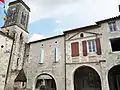 Kirche Saint-Pierre
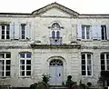 Hôtel Cours de Thomazeau
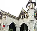 Markthalle