Sainte-Colombe-de-Villeneuve
Sainte-Colombe-de-Villeneuve ist eine französische Gemeinde mit 502 Einwohnern (Stand: 1. Januar 2019) im Département Lot-et-Garonne in der Region Nouvelle-Aquitaine. Sie gehört zum Arrondissement Villeneuve-sur-Lot und zum Kanton Villeneuve-sur-Lot-2.
| Sainte-Colombe-de-Villeneuve | ||
|---|---|---|
| ||
| Staat | Frankreich | |
| Region | Nouvelle-Aquitaine | |
| Département (Nr.) | Lot-et-Garonne (47) | |
| Arrondissement | Villeneuve-sur-Lot | |
| Kanton | Villeneuve-sur-Lot-2 | |
| Gemeindeverband | Grand Villeneuvois | |
| Koordinaten | 44° 22′ N, 0° 40′ O | |
| Höhe | 70–224 m | |
| Fläche | 19,01 km² | |
| Einwohner | 502 (1. Januar 2019) | |
| Bevölkerungsdichte | 26 Einw./km² | |
| Postleitzahl | 47300 | |
| INSEE-Code | 47237 | |

Geografie
Sainte-Colombe-de-Villeneuve liegt etwa fünf Kilometer südwestlich von Villeneuve-sur-Lot. Umgeben wird Sainte-Colombe-de-Villeneuve von den Nachbargemeinden Bias im Norden, Pujols im Osten, Saint-Antoine-de-Ficalba im Südosten, Castella im Süden und Südosten, Sembas im Süden, Dolmayrac im Westen und Südwesten sowie Allez-et-Cazeneuve im Westen und Nordwesten.
Bevölkerungsentwicklung
| Jahr | 1962 | 1968 | 1975 | 1982 | 1990 | 1999 | 2006 | 2018 |
| Einwohner | 387 | 337 | 279 | 326 | 330 | 364 | 403 | 496 |
| Quellen: Cassini und INSEE | ||||||||
Sehenswürdigkeiten
- Kirche Sainte-Colombe
- Kirche Sainte-Madeleine in Laurier, seit 1926 Monument historique
- Höhle von Lastournelle
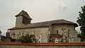 Kirche Sainte-Colombe
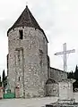 Kirche Sainte-Madeleine
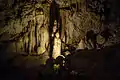 Statue in der Höhe von Lastournelle
This article is issued from Wikipedia. The text is licensed under Creative Commons - Attribution - Sharealike. The authors of the article are listed here. Additional terms may apply for the media files, click on images to show image meta data.