Montastruc (Lot-et-Garonne)
Montastruc (okzitanisch gleichlautend) ist eine französische Stadt mit 246 Einwohnern (Stand: 1. Januar 2019) im Département Lot-et-Garonne in der Region Nouvelle-Aquitaine. Die Gemeinde liegt im Arrondissement Villeneuve-sur-Lot und ist Teil des Kantons Le Livradais. Die Einwohner werden Montastrucais genannt.
| Montastruc | ||
|---|---|---|
| ||
| Staat | Frankreich | |
| Region | Nouvelle-Aquitaine | |
| Département (Nr.) | Lot-et-Garonne (47) | |
| Arrondissement | Villeneuve-sur-Lot | |
| Kanton | Le Livradais | |
| Gemeindeverband | Lot et Tolzac | |
| Koordinaten | 44° 29′ N, 0° 31′ O | |
| Höhe | 62–195 m | |
| Fläche | 24,85 km² | |
| Einwohner | 246 (1. Januar 2019) | |
| Bevölkerungsdichte | 10 Einw./km² | |
| Postleitzahl | 47380 | |
| INSEE-Code | 47182 | |

Geographie
Montastruc liegt etwa 32 Kilometer nordnordwestlich von Agen. Montastruc wird umgeben von den Nachbargemeinden Monbahus im Norden, Beaugas im Nordosten, Pinel-Hauterive im Osten, Monclar im Süden, Coulx im Südwesten, Tombebœuf im Westen sowie Villebramar im Nordwesten.
Bevölkerungsentwicklung
| 1962 | 1968 | 1975 | 1982 | 1990 | 1999 | 2006 | 2018 |
|---|---|---|---|---|---|---|---|
| 464 | 431 | 381 | 357 | 309 | 276 | 279 | 251 |
| Quellen: Cassini und INSEE | |||||||
Sehenswürdigkeiten
- Kirche Saint-Étienne aus dem 14. Jahrhundert
- Kirche Saint-Pierre-de-la-Croix im Ortsteil Le Colombier aus dem 16. Jahrhundert, seit 1997 Monument historique
- frühere Kirche Saint-Étienne in Périllac
- Kirche Saint-Pierre im Ortsteil Bourdie
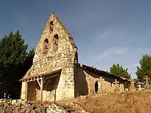
Kirche Saint-Pierre im Ortsteil Bourdie
This article is issued from Wikipedia. The text is licensed under Creative Commons - Attribution - Sharealike. The authors of the article are listed here. Additional terms may apply for the media files, click on images to show image meta data.