Kanton Le Fumélois
Der Kanton Le Fumélois ist ein französischer Wahlkreis im Arrondissement Villeneuve-sur-Lot, im Département Lot-et-Garonne und in der Region Nouvelle-Aquitaine; sein Hauptort ist Fumel.
| Kanton Le Fumélois | |
|---|---|
| Region | Nouvelle-Aquitaine |
| Département | Lot-et-Garonne |
| Arrondissement | Villeneuve-sur-Lot |
| Hauptort | Fumel |
| Einwohner | 17.821 (1. Jan. 2019) |
| Bevölkerungsdichte | 55 Einw./km² |
| Fläche | 326,59 km² |
| Gemeinden | 19 |
| INSEE-Code | 4709 |
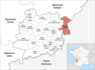 Lage des Kantons Le Fumélois im Département Lot-et-Garonne | |
Gemeinden
Der Kanton besteht aus 19 Gemeinden mit insgesamt 17.821 Einwohnern (Stand: 1. Januar 2019) auf einer Gesamtfläche von 326,59 km²:
| Gemeinde | Einwohner 1. Januar 2019 |
Fläche km² |
Dichte Einw./km² |
Code INSEE |
Postleitzahl |
|---|---|---|---|---|---|
| Anthé | 199 | 14,19 | 14 | 47011 | 47370 |
| Blanquefort-sur-Briolance | 495 | 42,05 | 12 | 47029 | 47500 |
| Bourlens | 375 | 15,66 | 24 | 47036 | 47370 |
| Cazideroque | 238 | 12,06 | 20 | 47064 | 47370 |
| Condezaygues | 850 | 10,89 | 78 | 47070 | 47500 |
| Courbiac | 108 | 9,08 | 12 | 47072 | 47370 |
| Cuzorn | 851 | 23,55 | 36 | 47077 | 47500 |
| Fumel | 4.755 | 22,79 | 209 | 47106 | 47500 |
| Lacapelle-Biron | 418 | 13,88 | 30 | 47123 | 47150 |
| Masquières | 183 | 11,36 | 16 | 47160 | 47370 |
| Monsempron-Libos | 2.033 | 8,97 | 227 | 47179 | 47500 |
| Montayral | 2.652 | 25,02 | 106 | 47185 | 47500 |
| Saint-Front-sur-Lémance | 518 | 19,77 | 26 | 47242 | 47500 |
| Saint-Georges | 550 | 15,97 | 34 | 47328 | 47370 |
| Saint-Vite | 1.163 | 5,52 | 211 | 47283 | 47500 |
| Sauveterre-la-Lémance | 576 | 23,58 | 24 | 47292 | 47500 |
| Thézac | 200 | 11,28 | 18 | 47307 | 47370 |
| Tournon-d’Agenais | 761 | 21,44 | 35 | 47312 | 47370 |
| Trentels | 896 | 19,53 | 46 | 47315 | 47140 |
| Kanton Le Fumélois | 17.821 | 326,59 | 55 | 4709 | – |
This article is issued from Wikipedia. The text is licensed under Creative Commons - Attribution - Sharealike. The authors of the article are listed here. Additional terms may apply for the media files, click on images to show image meta data.