Monflanquin
Monflanquin ist eine französische Gemeinde mit 2329 Einwohnern (Stand 1. Januar 2019) im Département Lot-et-Garonne in der Region Nouvelle-Aquitaine. Sie gehört zum Arrondissement Villeneuve-sur-Lot und zum Kanton Le Haut Agenais Périgord.
| Monflanquin | ||
|---|---|---|
.svg.png.webp)
|
| |
| Staat | Frankreich | |
| Region | Nouvelle-Aquitaine | |
| Département (Nr.) | Lot-et-Garonne (47) | |
| Arrondissement | Villeneuve-sur-Lot | |
| Kanton | Le Haut Agenais Périgord | |
| Gemeindeverband | Bastides en Haut Agenais Périgord | |
| Koordinaten | 44° 32′ N, 0° 46′ O | |
| Höhe | 64–207 m | |
| Fläche | 62,35 km² | |
| Einwohner | 2.329 (1. Januar 2019) | |
| Bevölkerungsdichte | 37 Einw./km² | |
| Postleitzahl | 47150 | |
| INSEE-Code | 47175 | |
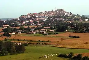 Blick auf Monflanquin | ||

Geografie
Monflanquin liegt auf einem Hügel oberhalb des Lède-Tals an der Grenze von Périgord, Quercy und Guyenne. Der Ort gehört zu den schönsten Dörfern Frankreichs.
Bevölkerungsentwicklung
| Jahr | 1962 | 1968 | 1975 | 1982 | 1990 | 1999 | 2007 | 2018 |
| Einwohner | 2308 | 2354 | 2368 | 2356 | 2431 | 2258 | 2342 | 2321 |
Sehenswürdigkeiten
- Kirche Saint-André (1250/90, Monument historique)
- Haus Du Prince Noir (14. Jahrhundert)
- Burg Roquefère
 Kirche Saint-André
 Prince Noir
Persönlichkeiten
- Pierre Saint-Amant (1800–1872), Schachspieler
This article is issued from Wikipedia. The text is licensed under Creative Commons - Attribution - Sharealike. The authors of the article are listed here. Additional terms may apply for the media files, click on images to show image meta data.