Moulinet (Lot-et-Garonne)
Moulinet ist eine französische Gemeinde mit 199 Einwohnern (Stand 1. Januar 2019) im Département Lot-et-Garonne in der Region Nouvelle-Aquitaine.
| Moulinet | ||
|---|---|---|
| ||
| Staat | Frankreich | |
| Region | Nouvelle-Aquitaine | |
| Département (Nr.) | Lot-et-Garonne (47) | |
| Arrondissement | Villeneuve-sur-Lot | |
| Kanton | Le Haut Agenais Périgord | |
| Gemeindeverband | Bastides en Haut Agenais Périgord | |
| Koordinaten | 44° 33′ N, 0° 35′ O | |
| Höhe | 83–170 m | |
| Fläche | 14,71 km² | |
| Einwohner | 199 (1. Januar 2019) | |
| Bevölkerungsdichte | 14 Einw./km² | |
| Postleitzahl | 47290 | |
| INSEE-Code | 47193 | |
_-1.JPG.webp) Mairie und ehemalige Grundschule | ||

Geografie
Moulinet liegt etwa 100 Kilometer südöstlich von Bordeaux.
Bevölkerung
| Jahr | 1962 | 1968 | 1975 | 1982 | 1990 | 1999 | 2008 | 2018 |
|---|---|---|---|---|---|---|---|---|
| Einwohner | 280 | 240 | 214 | 199 | 222 | 217 | 203 | 199 |
Sehenswürdigkeiten
- Kirche Saint-Jean im Ortsteil Lasbardes aus dem 12. Jahrhundert
- Kirche Saint-Ferréol im Ortsteil Lentignac aus dem 12. Jahrhundert
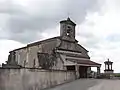 Kirche Saint-Jean
 Kirche Saint-Ferréol
This article is issued from Wikipedia. The text is licensed under Creative Commons - Attribution - Sharealike. The authors of the article are listed here. Additional terms may apply for the media files, click on images to show image meta data.