Saint-Louis-en-l’Isle
Saint-Louis-en-l’Isle (okzitanisch: Sent Lóis d’Eila) ist eine französische Gemeinde in der Region Nouvelle-Aquitaine (vor 2016: Aquitanien) mit 304 Einwohnern (Stand: 1. Januar 2019). Sie liegt im Département Dordogne. Die Gemeinde gehört zum Kanton Vallée de l’Isle im Arrondissement Périgueux.
| Saint-Louis-en-l’Isle Sent Lóis d’Eila | ||
|---|---|---|

|
| |
| Staat | Frankreich | |
| Region | Nouvelle-Aquitaine | |
| Département (Nr.) | Dordogne (24) | |
| Arrondissement | Périgueux | |
| Kanton | Vallée de l’Isle | |
| Gemeindeverband | Isle et Crempse en Périgord | |
| Koordinaten | 45° 4′ N, 0° 23′ O | |
| Höhe | 43–127 m | |
| Fläche | 2,80 km² | |
| Einwohner | 304 (1. Januar 2019) | |
| Bevölkerungsdichte | 109 Einw./km² | |
| Postleitzahl | 24400 | |
| INSEE-Code | 24444 | |
| Website | http://www.saint-louis-en-lisle.fr/ | |
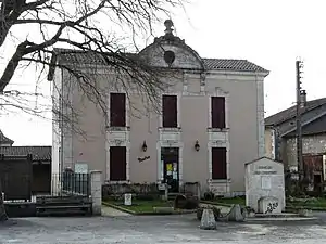 Rathaus (Mairie) von Saint-Louis-en-l’Isle | ||

Geografie
Saint-Louis-en-l’Isle liegt im Périgord Blanc (Weißes Périgord) am nördlichen Ufer der Isle. Umgeben wird Saint-Louis-en-l’Isle von den Nachbargemeinden Douzillac im Norden und Nordosten, Sourzac im Süden und Osten, Saint-Front-de-Pradoux im Westen sowie Beauronne im Nordwesten.
Bevölkerungsentwicklung
| Jahr | 1962 | 1968 | 1975 | 1982 | 1990 | 1999 | 2006 | 2018 |
| Einwohner | 209 | 204 | 241 | 220 | 233 | 224 | 243 | 303 |
| Quellen: Cassini und INSEE | ||||||||
Sehenswürdigkeiten
- Kirche Saint-Louis aus dem 13. Jahrhundert
.JPG.webp)
Kirche Saint-Louis
This article is issued from Wikipedia. The text is licensed under Creative Commons - Attribution - Sharealike. The authors of the article are listed here. Additional terms may apply for the media files, click on images to show image meta data.