Gresswiller
| Gresswiller | ||
|---|---|---|

|
| |
| Staat | Frankreich | |
| Region | Grand Est | |
| Département (Nr.) | Bas-Rhin (67) | |
| Arrondissement | Molsheim | |
| Kanton | Mutzig | |
| Gemeindeverband | Région de Molsheim-Mutzig | |
| Koordinaten | 48° 32′ N, 7° 26′ O | |
| Höhe | 192–322 m | |
| Fläche | 9,55 km² | |
| Einwohner | 1.666 (1. Januar 2019) | |
| Bevölkerungsdichte | 174 Einw./km² | |
| Postleitzahl | 67190 | |
| INSEE-Code | 67168 | |
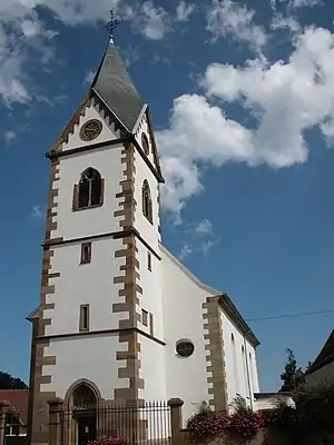 Kirche St. Martin in Gresswiller | ||

Gresswiller (dt. Greßweiler) ist eine französische Gemeinde mit 1666 Einwohnern (Stand 1. Januar 2019) im Département Bas-Rhin in der Region Grand Est (bis 2015 Elsass). Gresswiller ist Mitglied der Communauté de communes de la Région de Molsheim-Mutzig.
Geografie
Gresswiller liegt im Breuschtal und umfasst auch den Forêt de Gresswiller im Südwesten. Die Nachbargemeinden sind Dinsheim-sur-Bruche, Heiligenberg, Mollkirch, Mutzig und Rosenwiller.
Bevölkerungsentwicklung
| Jahr | 1962 | 1968 | 1975 | 1982 | 1990 | 1999 | 2007 | 2017 |
| Einwohner | 869 | 919 | 964 | 1052 | 1181 | 1287 | 1457 | 1696 |
Verkehr
Gresswiller liegt an der Bahnstrecke Strasbourg–Saint-Dié und wird von TER-Zügen bedient.
Literatur
- Le Patrimoine des Communes du Bas-Rhin. Flohic Editions, Band 1, Charenton-le-Pont 1999, ISBN 2-84234-055-8, S. 723–726.
This article is issued from Wikipedia. The text is licensed under Creative Commons - Attribution - Sharealike. The authors of the article are listed here. Additional terms may apply for the media files, click on images to show image meta data.