Gellainville
Gellainville ist eine französische Gemeinde mit 666 Einwohnern (Stand: 1. Januar 2019) im Département Eure-et-Loir in der Region Centre-Val de Loire. Sie gehört zum Arrondissement Chartres und zum Kanton Chartres-2 (bis 2015: Kanton Chartres-Sud-Est).
| Gellainville | ||
|---|---|---|
| ||
| Staat | Frankreich | |
| Region | Centre-Val de Loire | |
| Département (Nr.) | Eure-et-Loir (28) | |
| Arrondissement | Chartres | |
| Kanton | Chartres-2 | |
| Gemeindeverband | Chartres Métropole | |
| Koordinaten | 48° 25′ N, 1° 32′ O | |
| Höhe | 137–156 m | |
| Fläche | 12,01 km² | |
| Einwohner | 666 (1. Januar 2019) | |
| Bevölkerungsdichte | 55 Einw./km² | |
| Postleitzahl | 28630 | |
| INSEE-Code | 28177 | |
| Website | www.gellainville.fr | |

Geographie
Gellainville liegt etwa fünf Kilometer südöstlich vom Stadtzentrum von Chartres. Umgeben wird Gellainville von den Nachbargemeinden Chartres im Norden und Nordwesten, Nogent-le-Phaye im Nordosten, Sours im Osten, Berchères-les-Pierres im Süden und Südosten, Morancez im Westen und Südwesten sowie Le Coudray im Westen.
Bevölkerungsentwicklung
| 1962 | 1968 | 1975 | 1982 | 1990 | 1999 | 2006 | 2013 |
|---|---|---|---|---|---|---|---|
| 263 | 273 | 291 | 364 | 413 | 409 | 471 | 660 |
| Quelle: Cassini und INSEE | |||||||
Sehenswürdigkeiten
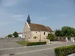
Kirche Saint-Jean-Baptiste
- Kirche Saint-Jean-Baptiste aus dem 12. Jahrhundert, Monument historique
Weblinks
Commons: Gellainville – Sammlung von Bildern, Videos und Audiodateien
This article is issued from Wikipedia. The text is licensed under Creative Commons - Attribution - Sharealike. The authors of the article are listed here. Additional terms may apply for the media files, click on images to show image meta data.