Gouillons
| Gouillons | ||
|---|---|---|
.svg.png.webp)
|
| |
| Staat | Frankreich | |
| Region | Centre-Val de Loire | |
| Département (Nr.) | Eure-et-Loir (28) | |
| Arrondissement | Chartres | |
| Kanton | Villages Vovéens | |
| Gemeindeverband | Cœur de Beauce | |
| Koordinaten | 48° 14′ N, 1° 33′ O | |
| Höhe | 137–148 m | |
| Fläche | 12,14 km² | |
| Einwohner | 342 (1. Januar 2019) | |
| Bevölkerungsdichte | 28 Einw./km² | |
| Postleitzahl | 28310 | |
| INSEE-Code | 28184 | |
| Website | https://www.gouillons.com/ | |
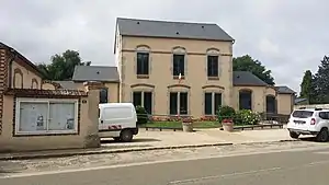 Rathaus (Mairie) von Gouillons | ||

Gouillons ist eine französische Gemeinde mit 342 Einwohnern (Stand: 1. Januar 2019) im Département Eure-et-Loir in der Region Centre-Val de Loire; sie gehört zum Arrondissement Chartres und zum Kanton Villages Vovéens (bis 2015: Kanton Janville).
Geographie
Gouillons liegt etwa 29 Kilometer ostsüdöstlich von Chartres. Umgeben wird Gouillons von den Nachbargemeinden Mondonville-Saint-Jean im Norden und Nordwesten, Léthuin im Norden und Nordosten, Châtenay im Osten und Nordosten, Baudreville im Osten und Südosten, Levesville-la-Chenard im Süden sowie Louville-la-Chenard im Westen und Südwesten.
Bevölkerungsentwicklung
| Jahr | 1962 | 1968 | 1975 | 1982 | 1990 | 1999 | 2006 | 2013 |
| Einwohner | 238 | 223 | 224 | 211 | 305 | 317 | 338 | 334 |
| Quelle: Cassini und INSEE | ||||||||
Sehenswürdigkeiten
- Kirche Saint-Mamert
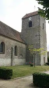
Kirche Saint-Mamert
Weblinks
Commons: Gouillons – Sammlung von Bildern, Videos und Audiodateien
This article is issued from Wikipedia. The text is licensed under Creative Commons - Attribution - Sharealike. The authors of the article are listed here. Additional terms may apply for the media files, click on images to show image meta data.