Dangers
Dangers ist eine Gemeinde im französischen Département Eure-et-Loir in der Verwaltungsregion Centre-Val de Loire. Sie gehört zum Kanton Illiers-Combray und zum Arrondissement Chartres. Nachbargemeinden sind Mittainvilliers-Vérigny im Westen und im Norden, Briconville im Osten und Bailleau-l’Évêque im Süden.
| Dangers | ||
|---|---|---|
| ||
| Staat | Frankreich | |
| Region | Centre-Val de Loire | |
| Département (Nr.) | Eure-et-Loir (28) | |
| Arrondissement | Chartres | |
| Kanton | Illiers-Combray | |
| Gemeindeverband | Communauté d’agglomération Chartres Métropole | |
| Koordinaten | 48° 31′ N, 1° 21′ O | |
| Höhe | 182–223 m | |
| Fläche | 7,37 km² | |
| Einwohner | 432 (1. Januar 2019) | |
| Bevölkerungsdichte | 59 Einw./km² | |
| Postleitzahl | 28190 | |
| INSEE-Code | 28128 | |

Bevölkerungsentwicklung
| Jahr | 1962 | 1968 | 1975 | 1982 | 1990 | 1999 | 2008 | 2015 |
|---|---|---|---|---|---|---|---|---|
| Einwohner | 192 | 209 | 266 | 315 | 328 | 382 | 412 | 425 |
Sehenswürdigkeiten
- Kirche Saint-Rémy
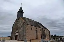
Kirche Saint-Rémy
Weblinks
Commons: Dangers (Eure-et-Loir) – Sammlung von Bildern, Videos und Audiodateien
This article is issued from Wikipedia. The text is licensed under Creative Commons - Attribution - Sharealike. The authors of the article are listed here. Additional terms may apply for the media files, click on images to show image meta data.