Trancrainville
Trancrainville ist eine französische Gemeinde mit 164 Einwohnern (Stand: 1. Januar 2019) im Département Eure-et-Loir in der Region Centre-Val de Loire; sie gehört zum Arrondissement Chartres und zum Kanton Villages Vovéens (bis 2015: Kanton Janville).
| Trancrainville | ||
|---|---|---|
| ||
| Staat | Frankreich | |
| Region | Centre-Val de Loire | |
| Département (Nr.) | Eure-et-Loir (28) | |
| Arrondissement | Chartres | |
| Kanton | Villages Vovéens | |
| Gemeindeverband | Cœur de Beauce | |
| Koordinaten | 48° 14′ N, 1° 52′ O | |
| Höhe | 124–142 m | |
| Fläche | 11,67 km² | |
| Einwohner | 164 (1. Januar 2019) | |
| Bevölkerungsdichte | 14 Einw./km² | |
| Postleitzahl | 28310 | |
| INSEE-Code | 28392 | |

Geographie
Trancrainville liegt etwa 35 Kilometer ostsüdöstlich von Chartres. Umgeben wird Trancrainville von den Nachbargemeinden Neuvy-en-Beauce im Norden, Oinville-Saint-Liphard im Osten, Le Puiset im Süden, Guilleville im Westen sowie Fresnay-l’Évêque im Nordwesten.
Durch die Gemeinde führt die Autoroute A10.
Bevölkerungsentwicklung
| Jahr | 1962 | 1968 | 1975 | 1982 | 1990 | 1999 | 2006 | 2013 |
| Einwohner | 252 | 268 | 224 | 182 | 159 | 170 | 159 | 175 |
| Quellen: Cassini und INSEE | ||||||||
Sehenswürdigkeiten
- Kirche Saint-Pierre aus dem 12. Jahrhundert
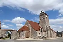
Kirche Saint-Pierre
Weblinks
Commons: Trancrainville – Sammlung von Bildern, Videos und Audiodateien
This article is issued from Wikipedia. The text is licensed under Creative Commons - Attribution - Sharealike. The authors of the article are listed here. Additional terms may apply for the media files, click on images to show image meta data.