Vilcey-sur-Trey
| Vilcey-sur-Trey | ||
|---|---|---|
|
| |
| Staat | Frankreich | |
| Region | Grand Est | |
| Département (Nr.) | Meurthe-et-Moselle (54) | |
| Arrondissement | Toul | |
| Kanton | Le Nord-Toulois | |
| Gemeindeverband | Mad et Moselle | |
| Koordinaten | 48° 56′ N, 5° 58′ O | |
| Höhe | 208–328 m | |
| Fläche | 13,54 km² | |
| Einwohner | 154 (1. Januar 2019) | |
| Bevölkerungsdichte | 11 Einw./km² | |
| Postleitzahl | 54700 | |
| INSEE-Code | 54566 | |

Vilcey-sur-Trey ist eine französische Gemeinde mit 154 Einwohnern (Stand: 1. Januar 2019) im Département Meurthe-et-Moselle in der Region Grand Est (bis 2015 Lothringen). Die Gemeinde gehört zum Arrondissement Toul und zum Kanton Le Nord-Toulois (bis 2015: Kanton Thiaucourt-Regniéville).
Geografie
Vilcey-sur-Trey liegt etwa 26 Kilometer südsüdöstlich von Metz im Regionalen Naturpark Lothringen. Umgeben wird Vilcey-sur-Trey von den Nachbargemeinden Prény im Norden und Nordosten, Vandières im Nordosten, Villers-sous-Prény im Osten, Norroy-lès-Pont-à-Mousson im Osten und Südosten, Fey-en-Haye im Süden, Thiaucourt-Regniéville im Westen und Südwesten sowie Viéville-en-Haye im Westen.
Bevölkerungsentwicklung
| Jahr | 1962 | 1968 | 1975 | 1982 | 1990 | 1999 | 2006 | 2013 |
| Einwohner | 158 | 182 | 153 | 166 | 153 | 155 | 166 | 151 |
| Quelle: Cassini und INSEE | ||||||||
Sehenswürdigkeiten
- Kirche Saint-Martin aus dem 18. Jahrhundert
- Prämonstratenser-Kloster Sainte-Marie-aux-Bois, um 1150 erbaut
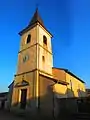 Kirche Saint-Martin
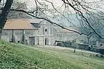 Kloster Sainte-Marie-aux-Bois
This article is issued from Wikipedia. The text is licensed under Creative Commons - Attribution - Sharealike. The authors of the article are listed here. Additional terms may apply for the media files, click on images to show image meta data.